Enable Location

We need your location to show you interesting places around you

Discover nearby places

Find interesting locations and hidden gems around you

Precise directions

Get accurate directions and distances to places

Your location is never shared with other users. It's only used when you tap the location button.

Yamhill River lock and dam

Log in to your account

Start exploring — it's free

Trusted by 63,026 travelers worldwide

Continue with Google
Continue with Apple
or

We will send you a code to connect

By continuing, you accept our Terms and Conditions and our Privacy Policy

Check your inbox

We've sent a pincode in your inbox. Please enter the code below.

Discussion Reviews 1 Photos
2.8k Popularity

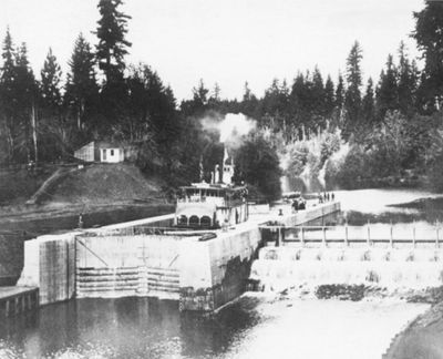
Yamhill River lock and dam, Historic lock and dam structure in Dayton, United States.

The Yamhill River lock is a water control structure on a river in Oregon that consists of a single chamber with concrete walls and connected dam structures. The facility allowed boats to move between different water levels while also regulating water flow for irrigation and navigation.

The lock was completed in 1900 by the U.S. Army Corps of Engineers to improve boat traffic between two river towns. Within a few decades after its opening, the intense use by river steamers declined as railroads and roads increasingly crossed the region.

The lock reflects the importance of river commerce for farmers who once shipped their goods downriver to larger markets. It shows how engineering solutions were directly tied to the economic life of rural communities in that era.

The site offers public walkways and viewing points from which the lock and its operation are clearly visible. It is best to wear comfortable shoes and bring weather protection appropriate to the season.

The lock is one of only three water control structures of its kind built on the Pacific Coast in the 19th century. Its preservation makes it a rare remnant of an era when river commerce defined connections between communities.

The community of curious travelers

AroundUs brings together thousands of curated places, local tips, and hidden gems, enriched daily by 60,000 contributors worldwide.

Start exploring
Location
Architects
United States Army Corps of Engineers
GPS coordinates
45.23060,-123.10400
Latest update
December 12, 2025 14:26
Around this place
Evergreen Aviation & Space Museum
United States of America

Evergreen Aviation & Space Museum

4.3 km
French Prairie
United States of America

French Prairie

12.5 km
Our Lady of Guadalupe Trappist Abbey
United States of America

Our Lady of Guadalupe Trappist Abbey

6 km
Hoover–Minthorn House
United States of America

Hoover–Minthorn House

13.1 km
St. Paul Roman Catholic Church
United States of America

St. Paul Roman Catholic Church

10.1 km
Evergreen Wings and Waves Waterpark
United States of America

Evergreen Wings and Waves Waterpark

4.7 km
Palmer House
United States of America

Palmer House

2.4 km
Hotel Oregon
United States of America

Hotel Oregon

7.4 km
Yamhill County Courthouse
United States of America

Yamhill County Courthouse

7.3 km
Pioneer Hall
United States of America

Pioneer Hall

8.1 km
Newberg Public Library
United States of America

Newberg Public Library

12.9 km
First Baptist Church
United States of America

First Baptist Church

2.5 km
Free Methodist Church
United States of America

Free Methodist Church

2.1 km
Minthorn Hall
United States of America

Minthorn Hall

13.4 km
Jesse Edwards House
United States of America

Jesse Edwards House

12.8 km
Evangelical United Brethren Church
United States of America

Evangelical United Brethren Church

2.3 km
Evangelical Church of Lafayette
United States of America

Evangelical Church of Lafayette

1.8 km
Paul Londershausen House
United States of America

Paul Londershausen House

2.4 km
John T. Hash House
United States of America

John T. Hash House

2.2 km
McMinnville Downtown Historic District
United States of America

McMinnville Downtown Historic District

7.5 km
Baxter House
United States of America

Baxter House

2.3 km
Methodist Episcopal Parsonage
United States of America

Methodist Episcopal Parsonage

2.3 km
Dr. Stuart House
United States of America

Dr. Stuart House

2.7 km
Gottlieb Londershausen House
United States of America

Gottlieb Londershausen House

2.4 km
Cameo Theatre
United States of America

Cameo Theatre

12.6 km
99 W Drive-In
United States of America

99 W Drive-In

14.8 km
Mack Theater
United States of America

Mack Theater

7.4 km
Ebenezer Chapel, Dayton, Oregon
United States of America

Ebenezer Chapel, Dayton, Oregon

9.2 km
Show the full map
Reviews
Share your experience

No review yet

Discussions
Start a discussion...

No discussion yet

« Yamhill River lock and dam - Historic lock and dam structure in Dayton, United States » is provided by Around Us (aroundus.com). Images and texts are derived from Wikimedia project under a Creative Commons license. You are allowed to copy, distribute, and modify copies of this page, under the conditions set by the license, as long as this note is clearly visible.

Discover hidden gems everywhere you go!

From secret cafés to breathtaking viewpoints, skip the crowded tourist spots and find places that match your style. Our app makes it easy with voice search, smart filtering, route optimization, and insider tips from travelers worldwide. Download now for the complete mobile experience.

Around Us App Screenshot

A unique approach to discovering new places

Le Figaro

All the places worth exploring

France Info

A tailor-made excursion in just a few clicks

20 Minutes

Around Us
Travel Guide & Maps
Download

Send to your phone

QR Code
1

Open the camera app on your mobile.

2

Point at the QR code with your camera. A notification will appear.

3

Tap the notification to open the link.