Enable Location

We need your location to show you interesting places around you

Discover nearby places

Find interesting locations and hidden gems around you

Precise directions

Get accurate directions and distances to places

Your location is never shared with other users. It's only used when you tap the location button.

William B. Umstead Bridge

Log in to your account

Start exploring — it's free

Trusted by 61,657 travelers worldwide

Continue with Google
Continue with Apple
or

We will send you a code to connect

By continuing, you accept our Terms and Conditions and our Privacy Policy

Check your inbox

We've sent a pincode in your inbox. Please enter the code below.

William B. Umstead Bridge

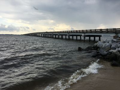
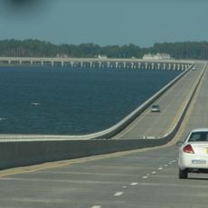
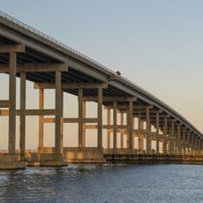
William B. Umstead Bridge, Road bridge in Dare County, United States.

Description

The William B. Umstead Bridge is a road bridge spanning Croatan Sound, connecting Manns Harbor with Roanoke Island. The structure carries US Route 64 and provides a vital link between the mainland and the island.

History

The bridge opened in 1955 and was the first major crossing structure in the Outer Banks region of North Carolina. It marked a turning point for connecting this remote island area to the mainland.

Culture

The bridge honors William B. Umstead, who served as North Carolina Governor and United States Senator before the structure's dedication in 1957.

Practical

The roadway is narrow and exposed, making it susceptible to strong winds and weather conditions. Planning your crossing for calmer times and allowing extra time during peak season helps ensure a safer journey.

Did you know?

The western section provides roosting habitat for around 100,000 purple martins during their yearly journey to South America. This unexpected bird concentration makes the span a seasonal location of biological interest.

Location
Inception
1955
Official opening
1955
GPS coordinates
35.91850,-75.74910
Latest update
December 12, 2025 17:46

AroundUs brings together thousands of curated places, local tips, and hidden gems, enriched daily by 60,000 contributors worldwide. Discover all places nearby (Dare County).

Around this place
Wright Brothers National Memorial
United States of America

Wright Brothers National Memorial

12.9 km
Jockey's Ridge State Park
United States of America

Jockey's Ridge State Park

11.4 km
Virginia Dare Memorial Bridge
United States of America

Virginia Dare Memorial Bridge

3.8 km
North Carolina Aquariums
United States of America

North Carolina Aquariums

4.1 km
Wright Brothers National Memorial
United States of America

Wright Brothers National Memorial

13.1 km
Roanoke Island Festival Park
United States of America

Roanoke Island Festival Park

7.5 km
Roanoke Marshes Light
United States of America

Roanoke Marshes Light

12.7 km
George Washington Creef House
United States of America

George Washington Creef House

7.1 km
Mattie Midgett Store and House
United States of America

Mattie Midgett Store and House

12 km
University of North Carolina - Coastal Studies Institute
United States of America

University of North Carolina - Coastal Studies Institute

9.4 km
John T. Daniels House
United States of America

John T. Daniels House

6.1 km
Queen Elizabeth I of England statue
United States of America

Queen Elizabeth I of England statue

4 km
Theodore S. Meekins House
United States of America

Theodore S. Meekins House

7 km
Wright Brothers Monument
United States of America

Wright Brothers Monument

12.9 km
Virginia Dare Monument
United States of America

Virginia Dare Monument

4.2 km
Washington Baum Bridge
United States of America

Washington Baum Bridge

11.1 km
First Flight Boulder
United States of America

First Flight Boulder

13.4 km
Fort Raleigh
United States of America

Fort Raleigh

4.2 km
December 17, 1903 Sculpture
United States of America

December 17, 1903 Sculpture

12.8 km
Waterside Theatre
United States of America

Waterside Theatre

4.3 km
Coastal North Carolina National Wildlife Refuges Gateway Visitor Center
United States of America

Coastal North Carolina National Wildlife Refuges Gateway Visitor Center

3.6 km
First Light of Freedom Memorial
United States of America

First Light of Freedom Memorial

4.1 km
Creef Cut Trail
United States of America

Creef Cut Trail

11.4 km
Elizabethan Gardens
United States of America

Elizabethan Gardens

4 km
1st Flight Marker
United States of America

1st Flight Marker

13.4 km
3rd Flight Marker
United States of America

3rd Flight Marker

13.5 km
2nd Flight Marker
United States of America

2nd Flight Marker

13.4 km
Reconstructed 1903 Camp Buildings
United States of America

Reconstructed 1903 Camp Buildings

13.4 km
Show the full map
« William B. Umstead Bridge - Road bridge in Dare County, United States » is provided by Around Us (aroundus.com). Images and texts are derived from Wikimedia project under a Creative Commons license. You are allowed to copy, distribute, and modify copies of this page, under the conditions set by the license, as long as this note is clearly visible.

Discover hidden gems everywhere you go!

From secret cafés to breathtaking viewpoints, skip the crowded tourist spots and find places that match your style. Our app makes it easy with voice search, smart filtering, route optimization, and insider tips from travelers worldwide. Download now for the complete mobile experience.

Around Us App Screenshot

A unique approach to discovering new places

Le Figaro

All the places worth exploring

France Info

A tailor-made excursion in just a few clicks

20 Minutes

Around Us
Travel Guide & Maps
Download

Send to your phone

QR Code
1

Open the camera app on your mobile.

2

Point at the QR code with your camera. A notification will appear.

3

Tap the notification to open the link.