Enable Location

We need your location to show you interesting places around you

Discover nearby places

Find interesting locations and hidden gems around you

Precise directions

Get accurate directions and distances to places

Your location is never shared with other users. It's only used when you tap the location button.

Virginia Dare Memorial Bridge

Log in to your account

Start exploring — it's free

Trusted by 63,003 travelers worldwide

Continue with Google
Continue with Apple
or

We will send you a code to connect

By continuing, you accept our Terms and Conditions and our Privacy Policy

Check your inbox

We've sent a pincode in your inbox. Please enter the code below.

Virginia Dare Memorial Bridge
Discussion Reviews 1 Photos
11.4k Popularity

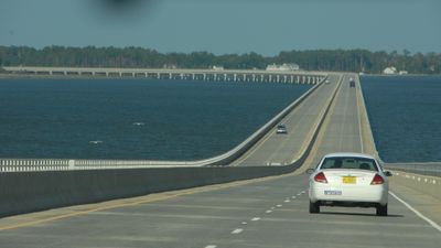
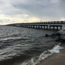
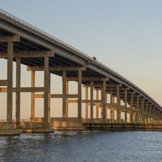
Virginia Dare Memorial Bridge, Road bridge in Dare County, United States

The Virginia Dare Memorial Bridge connects mainland North Carolina to the Outer Banks by crossing Croatan Sound between Manns Harbor and Roanoke Island. The structure is built from prestressed concrete and supported by a system of concrete columns.

The crossing opened in 2002 and was designed to improve transportation between the mainland and the barrier islands. The project represented a major infrastructure investment to better connect the region.

This crossing honors Virginia Dare, the first English child born in the colonies during the early settlement period. The namesake reflects how deeply that historical moment shaped the identity of this region.

The bridge rises higher in the middle to allow boats to pass underneath. For visitors traveling between the mainland and the islands, this is the main crossing point and serves as an emergency evacuation route during storms.

The structure rests on thousands of pilings that drive deep into the seabed below. This hidden anchor system is what keeps the entire crossing stable against storms and strong water currents.

The community of curious travelers

AroundUs brings together thousands of curated places, local tips, and hidden gems, enriched daily by 60,000 contributors worldwide.

Start exploring
Location
Inception
August 16, 2002
Official opening
August 16, 2002
Made from material
prestressed concrete
GPS coordinates
35.88700,-75.73250
Latest update
December 8, 2025 13:41
Around this place
Wright Brothers National Memorial
United States of America

Wright Brothers National Memorial

15.3 km
Bodie Island Light
United States of America

Bodie Island Light

17.1 km
Jockey's Ridge State Park
United States of America

Jockey's Ridge State Park

12.2 km
Alligator River National Wildlife Refuge
United States of America

Alligator River National Wildlife Refuge

15.7 km
North Carolina Aquariums
United States of America

North Carolina Aquariums

4.3 km
Wright Brothers National Memorial
United States of America

Wright Brothers National Memorial

15.6 km
Roanoke Island Festival Park
United States of America

Roanoke Island Festival Park

6.6 km
Roanoke Marshes Light
United States of America

Roanoke Marshes Light

8.9 km
William B. Umstead Bridge
United States of America

William B. Umstead Bridge

3.8 km
Sea Foam Motel
United States of America

Sea Foam Motel

12.5 km
Nags Head Beach Cottages Historic District
United States of America

Nags Head Beach Cottages Historic District

14.9 km
George Washington Creef House
United States of America

George Washington Creef House

6 km
Mattie Midgett Store and House
United States of America

Mattie Midgett Store and House

12.4 km
University of North Carolina - Coastal Studies Institute
United States of America

University of North Carolina - Coastal Studies Institute

6.6 km
John T. Daniels House
United States of America

John T. Daniels House

5 km
Queen Elizabeth I of England statue
United States of America

Queen Elizabeth I of England statue

6 km
Theodore S. Meekins House
United States of America

Theodore S. Meekins House

5.9 km
Wright Brothers Monument
United States of America

Wright Brothers Monument

15.3 km
Virginia Dare Monument
United States of America

Virginia Dare Monument

6 km
Washington Baum Bridge
United States of America

Washington Baum Bridge

9.3 km
First Flight Boulder
United States of America

First Flight Boulder

15.9 km
Fort Raleigh
United States of America

Fort Raleigh

6.1 km
December 17, 1903 Sculpture
United States of America

December 17, 1903 Sculpture

15.1 km
Waterside Theatre
United States of America

Waterside Theatre

6.2 km
Coastal North Carolina National Wildlife Refuges Gateway Visitor Center
United States of America

Coastal North Carolina National Wildlife Refuges Gateway Visitor Center

5.2 km
First Light of Freedom Memorial
United States of America

First Light of Freedom Memorial

5.9 km
Creef Cut Trail
United States of America

Creef Cut Trail

11.3 km
Elizabethan Gardens
United States of America

Elizabethan Gardens

6 km
Show the full map
Reviews
Share your experience

No review yet

Discussions
Start a discussion...

No discussion yet

« Virginia Dare Memorial Bridge - Road bridge in Dare County, United States » is provided by Around Us (aroundus.com). Images and texts are derived from Wikimedia project under a Creative Commons license. You are allowed to copy, distribute, and modify copies of this page, under the conditions set by the license, as long as this note is clearly visible.

Discover hidden gems everywhere you go!

From secret cafés to breathtaking viewpoints, skip the crowded tourist spots and find places that match your style. Our app makes it easy with voice search, smart filtering, route optimization, and insider tips from travelers worldwide. Download now for the complete mobile experience.

Around Us App Screenshot

A unique approach to discovering new places

Le Figaro

All the places worth exploring

France Info

A tailor-made excursion in just a few clicks

20 Minutes

Around Us
Travel Guide & Maps
Download

Send to your phone

QR Code
1

Open the camera app on your mobile.

2

Point at the QR code with your camera. A notification will appear.

3

Tap the notification to open the link.