Chest opened
+${chestReward.xp} XP
Explorer
NOUVEAU ×${chestReward.collectible.quantity}
tapez pour fermer
Chest locked

Open chests in the app

Around Us is built for your phone — chests unlock when you walk, explore and capture nearby places.

Enable Location

We need your location to show you interesting places around you

Discover nearby places

Find interesting locations and hidden gems around you

Precise directions

Get accurate directions and distances to places

Your location is never shared with other users. It's only used when you tap the location button.

Log in to your account

Start exploring — it's free

Trusted by 72,918 travelers worldwide

Continue with Google
Continue with Apple
or

We will send you a code to connect

By continuing, you accept our Terms and Conditions and our Privacy Policy

Check your inbox

We've sent a pincode in your inbox. Please enter the code below.

Whitehall State Park
Discussion Reviews Photo
3.2k Popularity

Whitehall State Park, State park in Hopkinton, United States.

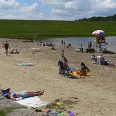
Whitehall State Park is an 837-acre nature preserve centered on a 592-acre reservoir, with numerous trails that wind through forests and along shorelines. The site includes a boat launch facility and is available for water recreation with enforced speed limits for boats.

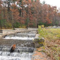
The park was established in 1947 after the reservoir stopped functioning as a water source for the Boston metropolitan area. This shift from a supply utility to a public recreation space marked a turning point for the land.

Local people come to fish on the ice during winter months, keeping alive a traditional outdoor activity that has been part of the community for many years. This practice shows how the park fits into the seasonal patterns of the region.

The park offers a boat ramp for water access, with motorboat speeds capped at 12 miles per hour (19 kilometers per hour). Dogs must be leashed in non-water areas, and visitors should prepare for changing weather conditions throughout the seasons.

A continuous loop trail of approximately 6 miles circles the entire reservoir, guiding hikers through different forest types and ecological zones as the terrain shifts. This circuit walk reveals the diverse ecosystems that have developed around the water body.

The community of curious travelers

AroundUs brings together thousands of curated places, local tips, and hidden gems, enriched daily by 60,000 contributors worldwide.

Start exploring
Location
Inception
1947
GPS coordinates
42.22917,-71.58278
Latest update
December 12, 2025 09:06
Around this place
Westborough State Hospital
United States of America

Westborough State Hospital

8.3 km
Lyman School for Boys
United States of America

Lyman School for Boys

7.5 km
Hopkinton State Park
United States of America

Hopkinton State Park

5.2 km
Ashland State Park
United States of America

Ashland State Park

9.5 km
Upton State Forest
United States of America

Upton State Forest

3 km
Willard House and Clock Museum
United States of America

Willard House and Clock Museum

7.5 km
Grafton Inn
United States of America

Grafton Inn

8.8 km
United States of America

John J. Carroll Water Treatment Plant

9.3 km
Farnumsville Historic District
United States of America

Farnumsville Historic District

10.3 km
Memorial Hall
United States of America

Memorial Hall

11 km
George Clapp House
United States of America

George Clapp House

8.3 km
Nathan Fisher House
United States of America

Nathan Fisher House

7 km
Fisherville Historic District
United States of America

Fisherville Historic District

10.9 km
Maples Cottage
United States of America

Maples Cottage

7.3 km
J.D.C. Bradley House
United States of America

J.D.C. Bradley House

10.3 km
Ash Street School
United States of America

Ash Street School

8.6 km
Grafton Public Library
United States of America

Grafton Public Library

8.8 km
Ashland Town House
United States of America

Ashland Town House

10.3 km
Jonah Warren House
United States of America

Jonah Warren House

2.7 km
Rockdale Common Housing District
United States of America

Rockdale Common Housing District

10.1 km
Ethan Allen House and Gun Shop
United States of America

Ethan Allen House and Gun Shop

10.2 km
South Union School
United States of America

South Union School

6.1 km
Upton Town Hall
United States of America

Upton Town Hall

6.2 km
Grafton Common Historic District
United States of America

Grafton Common Historic District

8.9 km
Vintonville Historic District
United States of America

Vintonville Historic District

4.7 km
Azariah Newton House
United States of America

Azariah Newton House

7.9 km
Upton Center Historic District
United States of America

Upton Center Historic District

6.4 km
Southborough Center Historic District
United States of America

Southborough Center Historic District

9.7 km
Show the full map
Reviews
Share your experience

No review yet

Discussions
Start a discussion...

No discussion yet

« Whitehall State Park - State park in Hopkinton, United States » is provided by Around Us (aroundus.com). Images and texts are derived from Wikimedia project under a Creative Commons license. You are allowed to copy, distribute, and modify copies of this page, under the conditions set by the license, as long as this note is clearly visible.

Discover hidden gems everywhere you go!

From secret cafés to breathtaking viewpoints, skip the crowded tourist spots and find places that match your style. Our app makes it easy with voice search, smart filtering, route optimization, and insider tips from travelers worldwide. Download now for the complete mobile experience.

Around Us App Screenshot

A unique approach to discovering new places

Le Figaro

All the places worth exploring

France Info

A tailor-made excursion in just a few clicks

20 Minutes

Around Us
Travel Guide & Maps
Download

Send to your phone

QR Code
1

Open the camera app on your mobile.

2

Point at the QR code with your camera. A notification will appear.

3

Tap the notification to open the link.