Mingo Falls

Log in to your account

AroundUs is a community-driven map of interesting places, built by curious explorers like you. It grows with every review, story, and photo you share.
Connect to save your favorite spots, contribute locations, and create personalized routes.
By continuing, you accept our Terms and Conditions and our Privacy Policy
Add to collection
Map
Suggest a change
Share

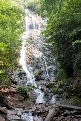
Mingo Falls, Waterfall in Qualla Boundary, United States.

Mingo Falls is a waterfall in Qualla Boundary that plunges 120 feet (37 meters) over granite boulders, creating a white sheet of water against the mountain rock face. The water flows along its natural course between steep cliff walls and forms a striking sight at the end of a forested hiking trail.

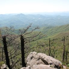
The waterfall sits on land managed by the Eastern Band of Cherokee Indians, who maintain this natural site within their sovereign territory adjacent to Great Smoky Mountains National Park. Its location reflects the ongoing importance of such places to Cherokee communities.

The name Mingo translates to Big Bear in the Cherokee language and reflects the heritage of the indigenous people in the surrounding Qualla Boundary. The falls are part of the Eastern Band of Cherokee Indians' territory, where this name continues to carry meaning for visitors and residents today.

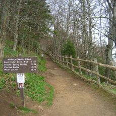
Visitors must climb 161 steep steps along the Pigeon Creek Trail to reach a wooden observation platform at the base of the falls. The path is narrow and requires good footwear and physical effort, especially during wet or humid conditions.

During winter months, sections of the falling water transform into ice formations while other parts continue to flow, creating an unusual blend of frozen and moving water. This seasonal shift gives the site a completely different appearance during the cold season.

Location: Cherokee

GPS coordinates: 35.53184,-83.27455

Latest update: December 8, 2025 20:02

Photos
Around this place
Show the full map
Great Smoky Mountains National Park
United States of America

Great Smoky Mountains National Park

16.2 km
Ghost Town in the Sky
United States of America

Ghost Town in the Sky

15.6 km
Oconaluftee Valley
United States of America

Oconaluftee Valley

3.3 km
Waterrock Knob
United States of America

Waterrock Knob

14.5 km
Oconaluftee Visitor Center
United States of America

Oconaluftee Visitor Center

3.5 km
Museum of the Cherokee Indian
United States of America

Museum of the Cherokee Indian

6.5 km
The Boulevard Trail
United States of America

The Boulevard Trail

17.6 km
Mount Chapman
United States of America

Mount Chapman

17.2 km
Jackson County Courthouse
United States of America

Jackson County Courthouse

18.1 km
Abel Hyatt House
United States of America

Abel Hyatt House

15.3 km
Elias Brendle Monteith House and Outbuildings
United States of America

Elias Brendle Monteith House and Outbuildings

17.9 km
Mingus Mill
United States of America

Mingus Mill

3.5 km
Mountain Farm Museum
United States of America

Mountain Farm Museum

3.5 km
John Davis House
United States of America

John Davis House

3.5 km
Smokemont Bridge
United States of America

Smokemont Bridge

3.9 km
Rockefeller Memorial
United States of America

Rockefeller Memorial

16.2 km
Oconaluftee Ranger Station
United States of America

Oconaluftee Ranger Station

3.5 km
Oconaluftee Indian Village
United States of America

Oconaluftee Indian Village

6.7 km
Oconaluftee Baptist Church
United States of America

Oconaluftee Baptist Church

3.9 km
Cataloochee Historic District
United States of America

Cataloochee Historic District

17.4 km
Oconaluftee Archeological District
United States of America

Oconaluftee Archeological District

3.3 km
Enloe Barn
United States of America

Enloe Barn

3.5 km
Mountainside Theatre
United States of America

Mountainside Theatre

6.6 km
Apple House
United States of America

Apple House

3.5 km
Blacksmith Shop
United States of America

Blacksmith Shop

3.4 km
Springhouse
United States of America

Springhouse

3.4 km
Corn Crib
United States of America

Corn Crib

3.5 km
Meathouse
United States of America

Meathouse

3.5 km
Show the full map
Reviews

Visited this place? Tap the stars to rate it and share your experience / photos with the community! Try now! You can cancel it anytime.

« Mingo Falls - Waterfall in Qualla Boundary, United States » is provided by Around Us (aroundus.com). Images and texts are derived from Wikimedia project under a Creative Commons license. You are allowed to copy, distribute, and modify copies of this page, under the conditions set by the license, as long as this note is clearly visible.

Discover hidden gems everywhere you go!

From secret cafés to breathtaking viewpoints, skip the crowded tourist spots and find places that match your style. Our app makes it easy with voice search, smart filtering, route optimization, and insider tips from travelers worldwide. Download now for the complete mobile experience.

Around Us App Screenshot

A unique approach to discovering new places

Le Figaro

All the places worth exploring

France Info

A tailor-made excursion in just a few clicks

20 Minutes