Sylamore Creek Bridge

Log in to your account

AroundUs is a community-driven map of interesting places, built by curious explorers like you. It grows with every review, story, and photo you share.
Connect to save your favorite spots, contribute locations, and create personalized routes.
Continue with Google
Continue with Apple
Continue with X
Continue with Facebook
Continue with email
By continuing, you accept our Terms and Conditions and our Privacy Policy
Create an account
Add to collection
Map
Suggest a change
Share

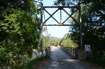
Sylamore Creek Bridge, Suspension bridge in Stone County, Arkansas, United States.

Sylamore Creek Bridge is a cable suspension structure spanning a creek in Stone County, supported by steel towers anchored in concrete foundations. The roadway narrows at 19 feet wide with clearance space of 11 feet, carrying local traffic over the waterway.

Built in 1945, the structure was added to the National Register of Historic Places in 1999 for its wire-cable suspension design. This recognition acknowledged its engineering approach typical of mid-twentieth century rural bridge construction.

The bridge served rural communities that needed reliable crossings over the creek, representing a practical solution tailored to local needs. It remains a symbol of how engineering adapted to serve small, distant settlements.

The bridge sits near Arkansas Highway 9, accessible by local roads in the Stone County area. Visitors can walk across to experience the structure and views from the deck level.

Only three wire-cable suspension bridges like this one remain in the entire state. Its specialized design by engineer N.B. Garver makes it distinct from bridge types built before or after this era.

Location: Stone County

GPS coordinates: 35.93583,-92.12167

Latest update: December 14, 2025 18:42

Photos
Around this place
Blanchard Springs Caverns
United States of America

Blanchard Springs Caverns

6.1 km
Stone County Courthouse
United States of America

Stone County Courthouse

7.5 km
Mount Olive Cumberland Presbyterian Church
United States of America

Mount Olive Cumberland Presbyterian Church

7.6 km
John Avey Barn
United States of America

John Avey Barn

13.8 km
Mirror Lake Historic District
United States of America

Mirror Lake Historic District

5.4 km
John F. Brewer House
United States of America

John F. Brewer House

7.6 km
Roasting Ear Church and School
United States of America

Roasting Ear Church and School

15.1 km
Lackey General Merchandise and Warehouse
United States of America

Lackey General Merchandise and Warehouse

7.5 km
Boswell School
United States of America

Boswell School

13.1 km
Jumbo Church of Christ
United States of America

Jumbo Church of Christ

18.9 km
Luber School
United States of America

Luber School

18.7 km
George W. Lackey House
United States of America

George W. Lackey House

7.4 km
Calico Rock Methodist Episcopal Church
United States of America

Calico Rock Methodist Episcopal Church

20.7 km
Calico Rock Historic District
United States of America

Calico Rock Historic District

20.4 km
Fred Lancaster Barn
United States of America

Fred Lancaster Barn

6.8 km
Noricks Chapel School
United States of America

Noricks Chapel School

19.1 km
Orvall Gammill Barn
United States of America

Orvall Gammill Barn

14 km
Mountain View Waterworks
United States of America

Mountain View Waterworks

7 km
Sylvester Smith Farmstead
United States of America

Sylvester Smith Farmstead

13.7 km
H.S. Mabry Barn
United States of America

H.S. Mabry Barn

12.9 km
Samuel Brown House
United States of America

Samuel Brown House

11.9 km
Clarence Anderson Barn
United States of America

Clarence Anderson Barn

12.8 km
West Richwoods Church & School
United States of America

West Richwoods Church & School

13 km
William Dillard Homestead
United States of America

William Dillard Homestead

7.9 km
Calico Rock Home Economics Building
United States of America

Calico Rock Home Economics Building

20.2 km
Clark-King House
United States of America

Clark-King House

5.7 km
Pinky Pruitt Barn
United States of America

Pinky Pruitt Barn

20 km
Mirror Lake Waterfall
United States of America

Mirror Lake Waterfall

5.4 km
Show the full map
Reviews

Visited this place? Tap the stars to rate it and share your experience / photos with the community! Try now! You can cancel it anytime.

« Sylamore Creek Bridge - Suspension bridge in Stone County, Arkansas, United States » is provided by Around Us (aroundus.com). Images and texts are derived from Wikimedia project under a Creative Commons license. You are allowed to copy, distribute, and modify copies of this page, under the conditions set by the license, as long as this note is clearly visible.

Discover hidden gems everywhere you go!

From secret cafés to breathtaking viewpoints, skip the crowded tourist spots and find places that match your style. Our app makes it easy with voice search, smart filtering, route optimization, and insider tips from travelers worldwide. Download now for the complete mobile experience.

Around Us App Screenshot

A unique approach to discovering new places

Le Figaro

All the places worth exploring

France Info

A tailor-made excursion in just a few clicks

20 Minutes