Enable Location

We need your location to show you interesting places around you

Discover nearby places

Find interesting locations and hidden gems around you

Precise directions

Get accurate directions and distances to places

Your location is never shared with other users. It's only used when you tap the location button.

Collin's Ford Bridge

Log in to your account

Start exploring — it's free

Trusted by 61,647 travelers worldwide

Continue with Google
Continue with Apple
or

We will send you a code to connect

By continuing, you accept our Terms and Conditions and our Privacy Policy

Check your inbox

We've sent a pincode in your inbox. Please enter the code below.

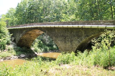
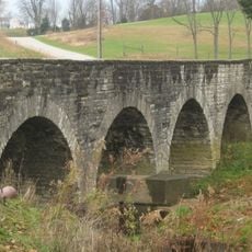
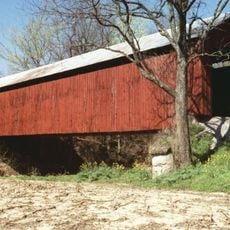
Collin's Ford Bridge, Stone arch road bridge in Shelby Township, Indiana.

Description

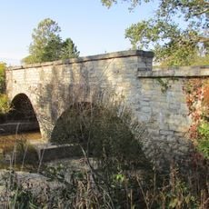
Collin's Ford Bridge is a stone arch road bridge with a two-span round-arch design in Shelby Township. The limestone structure displays typical features of early engineering construction, built to cross a waterway with its solid curved supports.

History

The bridge was built in 1907 by engineers James E. Wright and John Rogers to serve local transportation needs. The U.S. Army later acquired the surrounding area in 1941, making the structure part of a larger military property.

Culture

The bridge represents early twentieth-century engineering methods and received National Register of Historic Places designation in July 1996.

Practical

The bridge is located within Big Oaks National Wildlife Refuge, roughly a mile west of New Marion. You can reach it easily since it sits along an established road within the refuge area.

Did you know?

The structure was added to the National Register of Historic Places in 1996 under reference number 96000787. This recognition marks its importance as an example of early American bridge-building techniques.

Location
GPS coordinates
39.00806,-85.37056
Latest update
December 14, 2025 18:00

AroundUs brings together thousands of curated places, local tips, and hidden gems, enriched daily by 60,000 contributors worldwide. Discover all places nearby (Indiana).

Around this place
Clifty Falls State Park
United States of America

Clifty Falls State Park

29.2 km
Muscatatuck Urban Training Center
United States of America

Muscatatuck Urban Training Center

15.1 km
Big Oaks National Wildlife Refuge
United States of America

Big Oaks National Wildlife Refuge

6.9 km
Versailles State Park
United States of America

Versailles State Park

14.6 km
Madison Historic District
United States of America

Madison Historic District

29.6 km
Eleutherian College
United States of America

Eleutherian College

23.4 km
United States of America

Stream Cliff Farm

27.5 km
Carnegie Hall of Moores Hill College
United States of America

Carnegie Hall of Moores Hill College

26.7 km
Straber Ford Bridge
United States of America

Straber Ford Bridge

15.6 km
Tyson United Methodist Church
United States of America

Tyson United Methodist Church

12.3 km
Westport Covered Bridge
United States of America

Westport Covered Bridge

23.3 km
Lyman and Asenath Hoyt House
United States of America

Lyman and Asenath Hoyt House

23.5 km
Milan Masonic Lodge No. 31
United States of America

Milan Masonic Lodge No. 31

24.4 km
John Linsey Rand House
United States of America

John Linsey Rand House

20 km
Ripley County Courthouse
United States of America

Ripley County Courthouse

12.5 km
Versailles School and Tyson Auditorium
United States of America

Versailles School and Tyson Auditorium

12.2 km
Moores Hill United Methodist Church
United States of America

Moores Hill United Methodist Church

27.1 km
Mathias Wolf Farm
United States of America

Mathias Wolf Farm

27.8 km
Annadale
United States of America

Annadale

21.6 km
Central House
United States of America

Central House

22.2 km
Lemuel Allen Farm
United States of America

Lemuel Allen Farm

28.1 km
Crawford-Whitehead-Ross House
United States of America

Crawford-Whitehead-Ross House

30.2 km
Elias Conwell House
United States of America

Elias Conwell House

22.3 km
Vernon Historic District
United States of America

Vernon Historic District

21 km
Fernando G. Taylor House
United States of America

Fernando G. Taylor House

12.5 km
James Covered Bridge
United States of America

James Covered Bridge

24.8 km
Busching Covered Bridge
United States of America

Busching Covered Bridge

13.3 km
Shepard Bridge
United States of America

Shepard Bridge

8.5 km
Show the full map
« Collin's Ford Bridge - Stone arch road bridge in Shelby Township, Indiana » is provided by Around Us (aroundus.com). Images and texts are derived from Wikimedia project under a Creative Commons license. You are allowed to copy, distribute, and modify copies of this page, under the conditions set by the license, as long as this note is clearly visible.

Discover hidden gems everywhere you go!

From secret cafés to breathtaking viewpoints, skip the crowded tourist spots and find places that match your style. Our app makes it easy with voice search, smart filtering, route optimization, and insider tips from travelers worldwide. Download now for the complete mobile experience.

Around Us App Screenshot

A unique approach to discovering new places

Le Figaro

All the places worth exploring

France Info

A tailor-made excursion in just a few clicks

20 Minutes

Around Us
Travel Guide & Maps
Download

Send to your phone

QR Code
1

Open the camera app on your mobile.

2

Point at the QR code with your camera. A notification will appear.

3

Tap the notification to open the link.