Enable Location

We need your location to show you interesting places around you

Discover nearby places

Find interesting locations and hidden gems around you

Precise directions

Get accurate directions and distances to places

Your location is never shared with other users. It's only used when you tap the location button.

Versailles State Park

Log in to your account

Start exploring — it's free

Trusted by 65,815 travelers worldwide

Continue with Google
Continue with Apple
or

We will send you a code to connect

By continuing, you accept our Terms and Conditions and our Privacy Policy

Check your inbox

We've sent a pincode in your inbox. Please enter the code below.

Versailles State Park
Discussion Reviews 1 Photos
4.7k Popularity

Versailles State Park, State park in southeastern Indiana, US

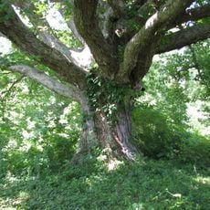
Versailles State Park is a nature reserve in southeastern Indiana built around a lake at the center of a large forested area. The grounds include hiking and biking trails, boating facilities, and a swimming pool open during summer.

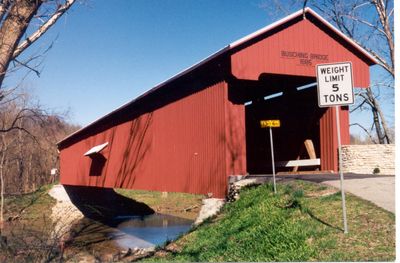
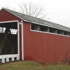
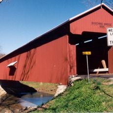
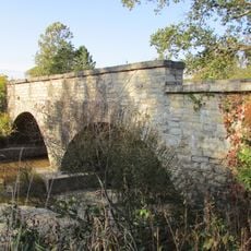
The park was established in 1943 to protect this forested area in southeastern Indiana. Within its grounds stands the Busching Bridge, a covered wooden structure from 1885 that still crosses Laughery Creek today.

The park hosts events like a Bluegrass Festival and a Pumpkin Show that draw people from across the region throughout the year. Attending one of these gatherings gives visitors a real sense of how local communities come together in this part of Indiana.

Some facilities are only open during warmer months, so it is worth checking conditions before you visit. Trails vary in difficulty, which makes the park a good option for both first-time hikers and those looking for a longer day out.

More than 230 bird species have been recorded in the park, including Bald Eagles that nest in the woods around the lake. Many visitors spot them without looking, simply by walking quietly along the trails near the water.

The community of curious travelers

AroundUs brings together thousands of curated places, local tips, and hidden gems, enriched daily by 60,000 contributors worldwide.

Start exploring
Location
Inception
1943
GPS coordinates
39.08000,-85.23000
Latest update
March 3, 2026 08:14
Around this place
Muscatatuck Urban Training Center
United States of America

Muscatatuck Urban Training Center

26.6 km
Big Oaks National Wildlife Refuge
United States of America

Big Oaks National Wildlife Refuge

20.6 km
Hillforest
United States of America

Hillforest

28.5 km
Carnegie Hall of Moores Hill College
United States of America

Carnegie Hall of Moores Hill College

12.4 km
Straber Ford Bridge
United States of America

Straber Ford Bridge

13.7 km
Collin's Ford Bridge
United States of America

Collin's Ford Bridge

14.6 km
George Street Bridge
United States of America

George Street Bridge

28.7 km
Tyson United Methodist Church
United States of America

Tyson United Methodist Church

2.3 km
Levi Stevens House
United States of America

Levi Stevens House

28.7 km
Milan Masonic Lodge No. 31
United States of America

Milan Masonic Lodge No. 31

9.9 km
Downtown Aurora Historic District
United States of America

Downtown Aurora Historic District

28.6 km
John Linsey Rand House
United States of America

John Linsey Rand House

14.7 km
Ripley County Courthouse
United States of America

Ripley County Courthouse

2.1 km
Versailles School and Tyson Auditorium
United States of America

Versailles School and Tyson Auditorium

2.4 km
Stockheughter Covered Bridge
United States of America

Stockheughter Covered Bridge

28.5 km
Leive, Parks and Stapp Opera House
United States of America

Leive, Parks and Stapp Opera House

28.5 km
First Methodist Church
United States of America

First Methodist Church

28.6 km
Aurora Public Library
United States of America

Aurora Public Library

28.5 km
Moores Hill United Methodist Church
United States of America

Moores Hill United Methodist Church

12.8 km
Central House
United States of America

Central House

16.3 km
Dearborn County Asylum for the Poor
United States of America

Dearborn County Asylum for the Poor

18.6 km
Elias Conwell House
United States of America

Elias Conwell House

16.5 km
Central Batesville Historic District
United States of America

Central Batesville Historic District

24.3 km
Fernando G. Taylor House
United States of America

Fernando G. Taylor House

2 km
Lewis Hurlbert, Sr. House
United States of America

Lewis Hurlbert, Sr. House

28.3 km
United States of America

Bischoff Reservoir

22 km
Busching Covered Bridge
United States of America

Busching Covered Bridge

1.5 km
Shepard Bridge
United States of America

Shepard Bridge

20.2 km
Show the full map
Reviews
Share your experience

No review yet

Discussions
Start a discussion...

No discussion yet

« Versailles State Park - State park in southeastern Indiana, US » is provided by Around Us (aroundus.com). Images and texts are derived from Wikimedia project under a Creative Commons license. You are allowed to copy, distribute, and modify copies of this page, under the conditions set by the license, as long as this note is clearly visible.

Discover hidden gems everywhere you go!

From secret cafés to breathtaking viewpoints, skip the crowded tourist spots and find places that match your style. Our app makes it easy with voice search, smart filtering, route optimization, and insider tips from travelers worldwide. Download now for the complete mobile experience.

Around Us App Screenshot

A unique approach to discovering new places

Le Figaro

All the places worth exploring

France Info

A tailor-made excursion in just a few clicks

20 Minutes

Around Us
Travel Guide & Maps
Download

Send to your phone

QR Code
1

Open the camera app on your mobile.

2

Point at the QR code with your camera. A notification will appear.

3

Tap the notification to open the link.