Enable Location

We need your location to show you interesting places around you

Discover nearby places

Find interesting locations and hidden gems around you

Precise directions

Get accurate directions and distances to places

Your location is never shared with other users. It's only used when you tap the location button.

Powell Bridge

Log in to your account

Start exploring — it's free

Trusted by 63,397 travelers worldwide

Continue with Google
Continue with Apple
or

We will send you a code to connect

By continuing, you accept our Terms and Conditions and our Privacy Policy

Check your inbox

We've sent a pincode in your inbox. Please enter the code below.

Discussion Reviews 1 Photos
1.5k Popularity

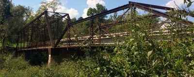
Powell Bridge, Road bridge in McDonald County, Missouri, United States

Powell Bridge is a steel road crossing in McDonald County that carries vehicles over a valley or waterway with a straightforward, functional design. The structure features steel supports and a solid deck that has served traffic continuously since its construction era.

The bridge was built in 1915 using early twentieth-century steel construction methods that proved practical and durable. Its later listing in the National Register of Historic Places reflected recognition of its importance to local transportation development.

The National Register of Historic Places designation of Powell Bridge underscores its role in the development of transportation systems in Missouri.

The crossing remains open to through traffic and accessible for viewing the structure up close from both sides. Visitors can walk or drive across to observe the construction details and engineering approach from different angles.

The preservation requirements for Powell Bridge maintain specific engineering features from 1915, including original construction elements and design characteristics.

The community of curious travelers

AroundUs brings together thousands of curated places, local tips, and hidden gems, enriched daily by 60,000 contributors worldwide.

Start exploring
Location
Inception
1910s
GPS coordinates
36.61608,-94.18201
Latest update
December 14, 2025 15:00
Around this place
Crystal Bridges Museum of American Art
United States of America

Crystal Bridges Museum of American Art

26.1 km
Mildred B. Cooper Memorial Chapel
United States of America

Mildred B. Cooper Memorial Chapel

16.5 km
Wonderland Cave
United States of America

Wonderland Cave

20.4 km
Lake Windsor
United States of America

Lake Windsor

19 km
Scott Family Amazeum
United States of America

Scott Family Amazeum

26.4 km
Big Sugar Creek State Park
United States of America

Big Sugar Creek State Park

10 km
Old High Middle School
United States of America

Old High Middle School

27.1 km
Jacobs Cavern
United States of America

Jacobs Cavern

14.4 km
Old McDonald County Courthouse
United States of America

Old McDonald County Courthouse

18.2 km
21c Museum Hotel Bentonville
United States of America

21c Museum Hotel Bentonville

27 km
Miller Homestead
United States of America

Miller Homestead

20.6 km
Rice House
United States of America

Rice House

26.6 km
New Home School and Church
United States of America

New Home School and Church

22.8 km
Braithwaite House
United States of America

Braithwaite House

25.4 km
Bella Vista Water Tank
United States of America

Bella Vista Water Tank

21.7 km
Macon-Harrison House
United States of America

Macon-Harrison House

27.1 km
Shady Grove School
United States of America

Shady Grove School

15.8 km
Banks House
United States of America

Banks House

25.2 km
Smith House
United States of America

Smith House

26.3 km
Blackwell-Paisley Cabin
United States of America

Blackwell-Paisley Cabin

21.2 km
Hagler-Cole Cabin
United States of America

Hagler-Cole Cabin

21.1 km
Koons House
United States of America

Koons House

26.7 km
Pea Ridge Commercial Historic District
United States of America

Pea Ridge Commercial Historic District

18.9 km
Deaton Cabin
United States of America

Deaton Cabin

21.2 km
Bertschy House
United States of America

Bertschy House

26.7 km
Princedom Cabin
United States of America

Princedom Cabin

21.4 km
Lentz-Carter Merchandise Store
United States of America

Lentz-Carter Merchandise Store

16.1 km
The Way of Color
United States of America

The Way of Color

26.6 km
Show the full map
Reviews
Share your experience

No review yet

Discussions
Start a discussion...

No discussion yet

« Powell Bridge - Road bridge in McDonald County, Missouri, United States » is provided by Around Us (aroundus.com). Images and texts are derived from Wikimedia project under a Creative Commons license. You are allowed to copy, distribute, and modify copies of this page, under the conditions set by the license, as long as this note is clearly visible.

Discover hidden gems everywhere you go!

From secret cafés to breathtaking viewpoints, skip the crowded tourist spots and find places that match your style. Our app makes it easy with voice search, smart filtering, route optimization, and insider tips from travelers worldwide. Download now for the complete mobile experience.

Around Us App Screenshot

A unique approach to discovering new places

Le Figaro

All the places worth exploring

France Info

A tailor-made excursion in just a few clicks

20 Minutes

Around Us
Travel Guide & Maps
Download

Send to your phone

QR Code
1

Open the camera app on your mobile.

2

Point at the QR code with your camera. A notification will appear.

3

Tap the notification to open the link.