Enable Location

We need your location to show you interesting places around you

Discover nearby places

Find interesting locations and hidden gems around you

Precise directions

Get accurate directions and distances to places

Your location is never shared with other users. It's only used when you tap the location button.

Log in to your account

Start exploring — it's free

Trusted by 62,440 travelers worldwide

Continue with Google
Continue with Apple
or

We will send you a code to connect

By continuing, you accept our Terms and Conditions and our Privacy Policy

Check your inbox

We've sent a pincode in your inbox. Please enter the code below.

Mohawk River State Park

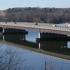
Mohawk River State Park, Nature preserve in Niskayuna, United States.

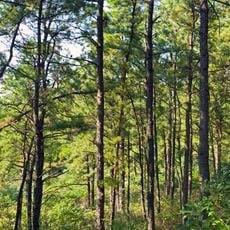
Mohawk River State Park is a nature preserve stretching along the Mohawk River with wooded sections, open spaces, and walking trails through undeveloped land. The site includes multiple access points and connects to the regional network of cycling and hiking routes.

The park was founded in 2006 when New York State acquired the land and established the first state park in Schenectady County. In 2024, the state transferred the entire property to the Town of Niskayuna with an agreement to maintain its natural condition.

Local volunteer groups maintain the John F. Brown Trail System within the park, fostering community involvement in outdoor recreation and conservation.

You can enter the site through a parking area on Whitmyer Drive, where trails begin. The location works well for walking and biking activities and provides easy access to the local trail network.

The park was taken over by the Town of Niskayuna in 2024 for just one dollar, an unusual agreement between state and local government. This symbolic price shows their shared commitment to protecting the natural area for the future.

The community of curious travelers

AroundUs brings together thousands of curated places, local tips, and hidden gems, enriched daily by 60,000 contributors worldwide.

Start exploring
Location
GPS coordinates
42.80360,-73.85150
Latest update
December 13, 2025 17:10
Around this place
Albany Pine Bush
United States of America

Albany Pine Bush

11.1 km
General Electric Research Laboratory
United States of America

General Electric Research Laboratory

8.2 km
Thaddeus Kosciusko Bridge
United States of America

Thaddeus Kosciusko Bridge

7.5 km
Proctor's Theatre
United States of America

Proctor's Theatre

7.5 km
Nott Memorial
United States of America

Nott Memorial

6.6 km
Watervliet Shaker Historic District
United States of America

Watervliet Shaker Historic District

7.6 km
Empire State Aerosciences Museum
United States of America

Empire State Aerosciences Museum

9.1 km
Schenectady City Hall
United States of America

Schenectady City Hall

7.3 km
Dudley Observatory
United States of America

Dudley Observatory

6.8 km
United States of America

Latham Circle

9.6 km
Crescent Bridge
United States of America

Crescent Bridge

10 km
Great Flats Nature Trail
United States of America

Great Flats Nature Trail

10.8 km
Oakcliff
United States of America

Oakcliff

10.2 km
Casparus F. Pruyn House
United States of America

Casparus F. Pruyn House

10 km
Clifton Park Center Baptist Church and Cemetery
United States of America

Clifton Park Center Baptist Church and Cemetery

6.3 km
Irving Langmuir House
United States of America

Irving Langmuir House

5.7 km
Abraham Glen House
United States of America

Abraham Glen House

9.1 km
Verdoy Schoolhouse
United States of America

Verdoy Schoolhouse

6.2 km
Grooms Tavern Complex
United States of America

Grooms Tavern Complex

3.5 km
Bridge 8, Erie Canal
United States of America

Bridge 8, Erie Canal

6 km
Nathan Garnsey House
United States of America

Nathan Garnsey House

7.3 km
Vischer Ferry Historic District
United States of America

Vischer Ferry Historic District

2.8 km
Mohawk Valley Grange Hall
United States of America

Mohawk Valley Grange Hall

3.4 km
Cyrus Rexford House
United States of America

Cyrus Rexford House

6.6 km
Mandeville Gallery
United States of America

Mandeville Gallery

6.6 km
Noxon Bank Building
United States of America

Noxon Bank Building

9.9 km
Abraham Best House
United States of America

Abraham Best House

2.3 km
Bridge 10, Erie Canal
United States of America

Bridge 10, Erie Canal

7.1 km
Show the full map
« Mohawk River State Park - Nature preserve in Niskayuna, United States » is provided by Around Us (aroundus.com). Images and texts are derived from Wikimedia project under a Creative Commons license. You are allowed to copy, distribute, and modify copies of this page, under the conditions set by the license, as long as this note is clearly visible.

Discover hidden gems everywhere you go!

From secret cafés to breathtaking viewpoints, skip the crowded tourist spots and find places that match your style. Our app makes it easy with voice search, smart filtering, route optimization, and insider tips from travelers worldwide. Download now for the complete mobile experience.

Around Us App Screenshot

A unique approach to discovering new places

Le Figaro

All the places worth exploring

France Info

A tailor-made excursion in just a few clicks

20 Minutes

Around Us
Travel Guide & Maps
Download

Send to your phone

QR Code
1

Open the camera app on your mobile.

2

Point at the QR code with your camera. A notification will appear.

3

Tap the notification to open the link.