Enable Location

We need your location to show you interesting places around you

Discover nearby places

Find interesting locations and hidden gems around you

Precise directions

Get accurate directions and distances to places

Your location is never shared with other users. It's only used when you tap the location button.

Talbot Avenue bridge

Log in to your account

Start exploring — it's free

Trusted by 63,627 travelers worldwide

Continue with Google
Continue with Apple
or

We will send you a code to connect

By continuing, you accept our Terms and Conditions and our Privacy Policy

Check your inbox

We've sent a pincode in your inbox. Please enter the code below.

Talbot Avenue bridge
Discussion Reviews 1 Photos
2.1k Popularity

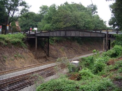
Talbot Avenue bridge, Railroad bridge in Silver Spring, Maryland, US.

Talbot Avenue bridge is a railroad overpass in Silver Spring that connects two neighborhoods across active rail lines. The structure was completely rebuilt and reopened in 2024 to restore vehicle passage between Lyttonsville and downtown areas.

The original structure dated to 1918 and served as a crucial connection for African American residents during segregation in the region. It was closed in 2017 due to structural safety concerns and replaced with a new design in 2024.

This bridge served as the main passage connecting two neighborhoods and shaped how residents moved through their community. For many families, crossing it was part of their daily routine and local identity.

The bridge is now open for vehicle traffic with two lanes across. Be aware that trains still operate on the rails below, so visibility and caution are important when crossing.

Before the old bridge was demolished in 2024, residents held a candlelit gathering where they signed farewell posters and shared memories of crossing it. The event showed how deeply the structure was woven into neighborhood life and identity.

The community of curious travelers

AroundUs brings together thousands of curated places, local tips, and hidden gems, enriched daily by 60,000 contributors worldwide.

Start exploring
GPS coordinates
39.00195,-77.04482
Latest update
December 13, 2025 17:00
Around this place
Washington D.C. Temple
United States of America

Washington D.C. Temple

2.3 km
National Museum of Health and Medicine
United States of America

National Museum of Health and Medicine

1.1 km
National Park Seminary
United States of America

National Park Seminary

1.4 km
Colonial Village
United States of America

Colonial Village

1.8 km
Columbia Country Club
United States of America

Columbia Country Club

3.5 km
AFI Silver Theatre
United States of America

AFI Silver Theatre

1.6 km
Acorn Park
United States of America

Acorn Park

1.9 km
Silver Spring Library
United States of America

Silver Spring Library

1.9 km
Polychrome Historic District
United States of America

Polychrome Historic District

3.1 km
Ohev Sholom - The National Synagogue
United States of America

Ohev Sholom - The National Synagogue

2.1 km
NOAA Central Library
United States of America

NOAA Central Library

1.6 km
Cady-Lee
United States of America

Cady-Lee

3.5 km
Woodend
United States of America

Woodend

1.9 km
Building 40
United States of America

Building 40

3.2 km
Juanita E. Thornton/Shepherd Park Neighborhood Library
United States of America

Juanita E. Thornton/Shepherd Park Neighborhood Library

2.9 km
Takoma Avenue Historic District
United States of America

Takoma Avenue Historic District

2.8 km
Top of the Park
United States of America

Top of the Park

3.2 km
Mihran Mesrobian House
United States of America

Mihran Mesrobian House

3.4 km
Northwest No. 9 Boundary Marker of the Original District of Columbia
United States of America

Northwest No. 9 Boundary Marker of the Original District of Columbia

2 km
Rock Creek Stream Valley Park
United States of America

Rock Creek Stream Valley Park

1.5 km
Sligo Creek Park
United States of America

Sligo Creek Park

1.8 km
Eleven55 Ripley
United States of America

Eleven55 Ripley

1.8 km
Noyes Library For Young Children
United States of America

Noyes Library For Young Children

3.5 km
Penguin Fountain
United States of America

Penguin Fountain

3.3 km
Discovery Building
United States of America

Discovery Building

1.6 km
Montgomery County Fire and Rescue Station 7
United States of America

Montgomery County Fire and Rescue Station 7

3 km
Chevy Chase Library
United States of America

Chevy Chase Library

3 km
Riley Spring Bridge
United States of America

Riley Spring Bridge

2.7 km
Show the full map
Reviews
Share your experience

No review yet

Discussions
Start a discussion...

No discussion yet

« Talbot Avenue bridge - Railroad bridge in Silver Spring, Maryland, US » is provided by Around Us (aroundus.com). Images and texts are derived from Wikimedia project under a Creative Commons license. You are allowed to copy, distribute, and modify copies of this page, under the conditions set by the license, as long as this note is clearly visible.

Discover hidden gems everywhere you go!

From secret cafés to breathtaking viewpoints, skip the crowded tourist spots and find places that match your style. Our app makes it easy with voice search, smart filtering, route optimization, and insider tips from travelers worldwide. Download now for the complete mobile experience.

Around Us App Screenshot

A unique approach to discovering new places

Le Figaro

All the places worth exploring

France Info

A tailor-made excursion in just a few clicks

20 Minutes

Around Us
Travel Guide & Maps
Download

Send to your phone

QR Code
1

Open the camera app on your mobile.

2

Point at the QR code with your camera. A notification will appear.

3

Tap the notification to open the link.