Enable Location

We need your location to show you interesting places around you

Discover nearby places

Find interesting locations and hidden gems around you

Precise directions

Get accurate directions and distances to places

Your location is never shared with other users. It's only used when you tap the location button.

Lake Estes

Log in to your account

Start exploring — it's free

Trusted by 62,222 travelers worldwide

Continue with Google
Continue with Apple
or

We will send you a code to connect

By continuing, you accept our Terms and Conditions and our Privacy Policy

Check your inbox

We've sent a pincode in your inbox. Please enter the code below.

Lake Estes

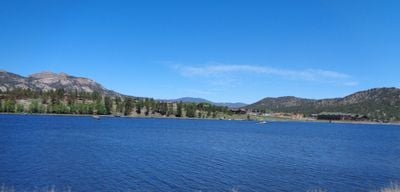
Lake Estes, man-made reservoir in Colorado, United States

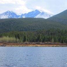
Lake Estes is a reservoir in Larimer County, Colorado, created by the Olympus Dam and covering about 185 acres. The water is used for boating, fishing, and paddling, with a paved trail around the shoreline offering walking and cycling routes with views of the surrounding mountains.

The lake was created in 1949 when the Olympus Dam, standing 70 feet high, was completed to provide drinking water for the growing town of Estes Park. A power plant on the western shore began generating electricity the following year and continues to support the area's infrastructure.

The marina offers pontoon boats, paddle boats, and kayaks for rent, with seasonal hours varying and extended availability from late May through early August. Visitors should know that swimming is not permitted, boating is restricted to daylight hours, and all passengers must wear lifejackets at all times on the water.

The lake serves as a crucial stopover for migratory birds, with species like Mergansers, Goldeneyes, and Warblers visiting or passing through depending on the season. Birdwatchers are often rewarded when visiting during early morning or late afternoon hours when these species are most active.

The community of curious travelers

AroundUs brings together thousands of curated places, local tips, and hidden gems, enriched daily by 60,000 contributors worldwide.

Start exploring
Location
GPS coordinates
40.37667,-105.48833
Latest update
February 7, 2026 11:00
Around this place
Chapel on the Rock
United States of America

Chapel on the Rock

15 km
Twin Sisters Peaks
United States of America

Twin Sisters Peaks

10.1 km
Beaver Meadows Visitor Center
United States of America

Beaver Meadows Visitor Center

6.2 km
East Longs Peak Trail – Longs Peak Trail – Keyhole Route – Shelf Trail
United States of America

East Longs Peak Trail – Longs Peak Trail – Keyhole Route – Shelf Trail

15.1 km
Fern Lake Trail
United States of America

Fern Lake Trail

12.3 km
Moraine Park Museum and Amphitheater
United States of America

Moraine Park Museum and Amphitheater

8.4 km
Snogo Snow Plow
United States of America

Snogo Snow Plow

6.2 km
McGraw Ranch
United States of America

McGraw Ranch

6.2 km
Park Theatre
United States of America

Park Theatre

2.9 km
William Allen White Cabins
United States of America

William Allen White Cabins

8.3 km
Glacier Basin Campground Ranger Station
United States of America

Glacier Basin Campground Ranger Station

10.5 km
Fall River Entrance Historic District
United States of America

Fall River Entrance Historic District

9.5 km
Rocky Mountain National Park Utility Area Historic District
United States of America

Rocky Mountain National Park Utility Area Historic District

6.3 km
Moraine Park Discovery Center
United States of America

Moraine Park Discovery Center

8.3 km
Lily Lake
United States of America

Lily Lake

8.9 km
Alberta Falls
United States of America

Alberta Falls

15.1 km
Estes Park Museum
United States of America

Estes Park Museum

1.3 km
Big Thompson Canyon
United States of America

Big Thompson Canyon

2.1 km
Fall River Visitor Center
United States of America

Fall River Visitor Center

8.8 km
Sheep Lakes Information Station
United States of America

Sheep Lakes Information Station

11.5 km
Many Parks Curve
United States of America

Many Parks Curve

12.2 km
Glacier Basin Campground
United States of America

Glacier Basin Campground

10.5 km
Sheep Lakes Turnout
United States of America

Sheep Lakes Turnout

11.5 km
Estes Park Aerial Tramway
United States of America

Estes Park Aerial Tramway

3 km
Moraine Park Amphitheater
United States of America

Moraine Park Amphitheater

8.4 km
Big Thompson River Bridge IV
United States of America

Big Thompson River Bridge IV

1.4 km
Rainbow Curve
United States of America

Rainbow Curve

15.1 km
Big Thompson River Bridge III
United States of America

Big Thompson River Bridge III

1.4 km
Show the full map
« Lake Estes - man-made reservoir in Colorado, United States » is provided by Around Us (aroundus.com). Images and texts are derived from Wikimedia project under a Creative Commons license. You are allowed to copy, distribute, and modify copies of this page, under the conditions set by the license, as long as this note is clearly visible.

Discover hidden gems everywhere you go!

From secret cafés to breathtaking viewpoints, skip the crowded tourist spots and find places that match your style. Our app makes it easy with voice search, smart filtering, route optimization, and insider tips from travelers worldwide. Download now for the complete mobile experience.

Around Us App Screenshot

A unique approach to discovering new places

Le Figaro

All the places worth exploring

France Info

A tailor-made excursion in just a few clicks

20 Minutes

Around Us
Travel Guide & Maps
Download

Send to your phone

QR Code
1

Open the camera app on your mobile.

2

Point at the QR code with your camera. A notification will appear.

3

Tap the notification to open the link.