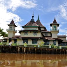
Bako National Park, National park in Kuching, Malaysia
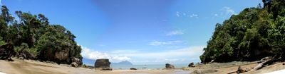
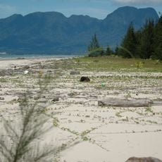
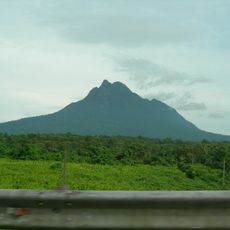
Bako National Park sits at the tip of the Muara Tebas peninsula in Sarawak and covers roughly 27 square kilometers with sandstone formations, coves and dense rainforest. The coastline alternates between rocky cliffs and small beach sections, while the interior is crossed by trails connecting different vegetation zones.
The park was established in 1957 as the first national park in Sarawak to protect the threatened ecosystems at the mouth of the Bako and Kuching rivers. The protection measures allowed the forests and coastal habitats to recover from earlier disturbances.
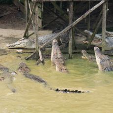
The name comes from the Bako River, which flows along the park boundary and serves as a natural landmark for visitors. The marked trails pass through mangrove swamps, peat forests and sandy coastal sections where walkers often encounter macaques and wild pigs.
The journey begins with a roughly 37-kilometer drive from Kuching to Kampung Bako, from where a roughly 20-minute boat ride reaches the park headquarters. The trails are divided into different lengths, so visitors can choose between short walks and half-day routes depending on fitness and available time.
The park is home to roughly 150 proboscis monkeys, which are found only in Borneo and are most visible at the mangrove edges during morning and evening. The wildlife also includes over 300 plant species and numerous bird species that nest in the different forest layers.
Location: Sarawak
Inception: 1957
GPS coordinates: 1.71667,110.46667
Latest update: December 5, 2025 22:31
Malaysia offers diverse photographic subjects from the Cameron Highlands with their tea plantations to the Petronas Towers in Kuala Lumpur. The landscape includes tropical rainforests in Borneo, limestone formations at Batu Caves, and coral reefs off the Perhentian Islands. Chinese temples in Georgetown, rice fields in Kedah, and mangrove forests in Langkawi complement the photographic opportunities. Architecture ranges from colonial buildings in Malacca to Hindu shrines and modern skyscrapers. The islands of Tioman and Sipadan attract underwater photographers, while Kinabatangan River provides wildlife photography opportunities. Urban markets, plantations, and coastal sections complete the offering for various photographic genres.
The Astana
21.7 km
Fort Margherita
21.7 km
Sarawak Stadium
18.5 km
Sarawak State Museum
22.6 km
Kuching Cat Museum
20.7 km
New Sarawak State Legislative Assembly Building
21.7 km
Planetarium Sultan Iskandar
23.2 km
Kuching Old Courthouse
22.1 km
Kuching Wetlands National Park
24.4 km
Tua Pek Kong Temple, Kuching
22.1 km
Sarawak State Library
19.7 km
Borneo Cultures Museum
22.6 km
St. Joseph's Cathedral, Kuching
23.1 km
Hong San Si Temple
22.1 km
Fort Alice
122.8 km
Islamic Heritage Museum
22.7 km
Chinese History Museum
22 km
Gunung Gading National Park
69.1 km
Alwatzikoebillah Place
144.8 km
Lanang Bridge
163 km
Ching San Yen Temple
8.1 km
Masjid Jami Keraton Sambas
144.8 km
Jong's Crocodile Farm and Zoo
36.8 km
Santubong National Park
16.9 km
Talang Satang National Park
34.2 km
Textile Museum Sarawak
22.2 km
Museum Daerah Kabupaten Sambas
135.9 km
Mount Santubong
15.1 kmVisited this place? Tap the stars to rate it and share your experience / photos with the community! Try now! You can cancel it anytime.
Discover hidden gems everywhere you go!
From secret cafés to breathtaking viewpoints, skip the crowded tourist spots and find places that match your style. Our app makes it easy with voice search, smart filtering, route optimization, and insider tips from travelers worldwide. Download now for the complete mobile experience.
A unique approach to discovering new places❞
— Le Figaro
All the places worth exploring❞
— France Info
A tailor-made excursion in just a few clicks❞
— 20 Minutes