Kuching Wetlands National Park, Coastal national park near Kuching, Malaysia
Kuching Wetlands National Park covers 66.1 km2 of estuarine reaches where the Sibu Laut and Salak rivers meet the sea, about 30 km from Kuching. Its saline, deltaic mangrove system forms an interlocking network of marine waterways and tidal creeks, with small patches of heath forest inside the boundary. It is the remnant of the former Sarawak Mangrove Forest Reserve, which covered 170 km2.
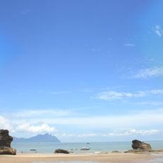
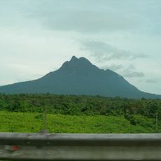
In the 12th century the area was a trading post where interior peoples exchanged jungle produce, mainly animal parts used in Chinese medicine, for Chinese pottery and earthenware. Excavations have unearthed remains of iron-smelting industries active hundreds of years ago. Mount Santubong served as a navigational landmark for these traders.
The park's name comes from the Malay "tanah lembap", meaning wetland, and it lies within Petra Jaya in the Kuching District. Local livelihoods still depend on the habitat: fish spawn among the mangrove roots, and timber is cut for construction and for several charcoal factories. Wildlife cruises are a growing source of income for people living around the reserve.
The park is best explored by boat since waterways form the main routes through the area. The best time to visit is during the dry season when conditions for navigating and wildlife viewing are more favorable.
The park protects at least three arboreal primates: the endangered proboscis monkey, long-tailed macaques and silvered langurs. Hairy-nosed otters and Irrawaddy dolphins have also been sighted in its waterways, and hornbills can be seen on nearby Mount Santubong.
The community of curious travelers
AroundUs brings together thousands of curated places, local tips, and hidden gems, enriched daily by 94,249 contributors worldwide.