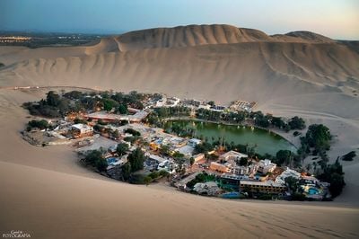
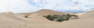
Huacachina, Desert oasis village in Ica, Peru
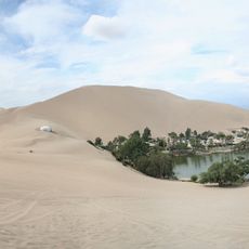
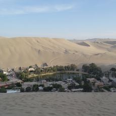
A natural desert lagoon sits amid towering sand dunes that rise up to 500 meters above the surrounding landscape in southwestern Peru. Palm trees line the shore of the greenish water body while a small cluster of hotels, restaurants and residential buildings encircles the lagoon. The dunes extend in all directions, forming a natural amphitheater formation around the water basin.
The name derives from Quechua language where wakachina means to guard or conceal, referencing the hidden location of the water source in the desert. By the mid-20th century, the place became known among travelers who used the purported therapeutic properties of the water. Tourism grew substantially from the 1990s onward as sandboarding and dune buggy rides attracted new visitors.
Folklore describes a princess fleeing a hunter who left behind her mirror, which transformed into the lagoon and gave the place its mythological importance in Peruvian storytelling. The oasis developed into a popular retreat for wealthy Lima families during the 20th century who sought healing in the mineral-rich waters.
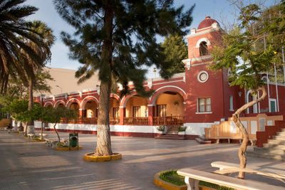
Visitors reach the location from nearby Ica city, positioned just five kilometers away with regular transportation connections available. Dune tours typically operate in late afternoon when temperatures drop and lighting improves for photography. ATMs and shops are located in Ica, while several accommodation options of varying categories are available around the lagoon perimeter.
The Peruvian government depicted this location on the 50 nuevo sol banknote in 1991, recognizing its position as South America's only desert oasis. Water levels have dropped considerably over recent decades, leading to installation of artificial pumping systems to maintain the lagoon for tourism purposes. Some buildings around the shore date from the 1940s and reflect early development as a resort destination.
Location: Ica Department
Elevation above the sea: 403 m
Address: Huacachina 11000, Peru 11000 Huacachina
GPS coordinates: -14.08750,-75.76333
Latest update: November 27, 2025 20:52
This collection leads to places that remain outside standard tourist circuits. The selection includes natural landscapes and cultural sites that receive limited attention from international visitors. From the salt flats of Bolivia to ancient ruins in Turkish mountain terrain and the ice formations of Lake Baikal, the collection provides access to less frequented regions. Natural phenomena include the Benagil Cave along Portugal's Algarve coast, the Great Blue Hole off Belize, and the sandstone formations of The Wave in Arizona. Cultural sites such as Quinta da Regaleira near Lisbon, the abandoned nitrate town of Humberstone in Chile, and the fortified Berber village of Ait Benhaddou in Morocco show historical building methods and past ways of life. The Meteora monasteries in Greece and the Waitomo glowworm caves in New Zealand demonstrate the connection between human settlement and natural environment. The locations span all continents and climate zones. They range from tropical regions like the turquoise river at Hinatuan in the Philippines, through temperate zones like the Cinchado rock formation on Tenerife, to remote areas such as Pangong Lake in Indian Ladakh and the limestone pinnacles of Tsingy de Bemaraha in Madagascar. The collection allows travelers to experience regional characteristics without commercial tourism infrastructure.
Looking for tranquility and disconnection? Here is a selection that ranges from scientific bases in Antarctica to remote villages in Tibet! These locations demonstrate human adaptation in the most inaccessible places. From meteorological stations in the Arctic to isolated communities on distant islands, these permanent establishments operate under extreme conditions. They include secret military bases, villages accessible only by helicopter, and territories where people live in total isolation.
Nazca Lines
95.9 km
Paracas National Reservation
47.2 km
Paracas Candelabra
67.3 km
Cañon de los Perdidos
79 km
Santuario del Señor de Luren
4.5 km
Tambo Colorado
43.1 km
Museo Maria Reiche
94.5 km
Museo Regional de Ica
3.6 km
La Centinela
83.5 km
Regional Conservation Area of Huacachina lagoon
2 km
Inka Wasi, Huancavelica
79.7 km
Hacienda San José
71.5 km
San José of Nazca church
94.4 km
Saint Xavier of Nazca church
88.9 km
Iglesia de San Juan Bautista, Huaytara
69.6 km
Nazca Lizard geoglyph
97.2 km
Nazca Pelican geoglyph
96.9 km
Nazca Tree geoglyph
97.2 km
Nazca Hands geoglyph
97.3 km
Nazca Condor Geoglyph
96.6 km
Nazca Monkey geoglyph
96.4 km
Nazca Spider geoglyph
96.6 km
Nazca Flamingo geoglyph
96.7 km
Nazca Frigate Bird geoglyph
96.8 km
Nazca Flower geoglyph
96.9 km
Nazca Mushroom geoglyph
95.9 km
Nazca Dog geoglyph
96.9 km
Nazca Hummingbird geoglyph
94.4 kmReviews
Visited this place? Tap the stars to rate it and share your experience / photos with the community! Try now! You can cancel it anytime.
Discover hidden gems everywhere you go!
From secret cafés to breathtaking viewpoints, skip the crowded tourist spots and find places that match your style. Our app makes it easy with voice search, smart filtering, route optimization, and insider tips from travelers worldwide. Download now for the complete mobile experience.
A unique approach to discovering new places❞
— Le Figaro
All the places worth exploring❞
— France Info
A tailor-made excursion in just a few clicks❞
— 20 Minutes