Amotape Hills National Park, Protected natural area in northern Piura and Tumbes regions, Peru.
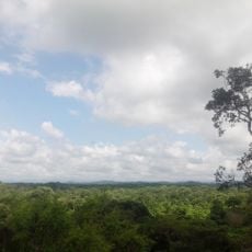
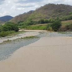
Cerros de Amotape National Park covers 151,561.27 hectares in the provinces of Tumbes, Contralmirante Villar and Sullana, from 120 m to 1,538 m in elevation. It takes in the Cordillera de los Amotapes and the Tumbes River, the only navigable river on Peru's coast, with rolling hills of dry forest and a wide pale riverbed of sand and shallow water.
Established on 22 July 1975, the park covers 151,561.27 hectares across the provinces of Tumbes, Contralmirante Villar and Sullana. In 1977 UNESCO made it a core zone of the Noroeste Amotapes-Manglares biosphere reserve. It protects the best-preserved equatorial dry forest on the Pacific coast.
The park's name comes from the Amotape hills it protects. In the El Caucho sector of the tropical forest zone, research facilities can be visited, and the park's checkpoints serve as places to stay overnight. Mules can be rented for longer routes inside the park, and canoeing is possible on the Tumbes River.
Entry requires a permit from the park director, requested through INRENA's office at Bartolomé Zeta no. 127, urb. José Lishner Tudela, Tumbes. From Tumbes, three routes reach control posts: via Francos to Rica Playa (about an hour), via Bocapán to Panales and Teniente Astete, or via Máncora to Fernández, the last 10 km on rough track. Checkpoints can be used to stay overnight, and mules can be rented for longer routes.
The park holds 14 threatened species, the highest count of any protected area in Peru, among them the grey-backed hawk, the grey-cheeked parakeet and the blackish-headed spinetail. Explorer Daniel López M. recently presented photographs of a banded owl for which no other records exist.
The community of curious travelers
AroundUs brings together thousands of curated places, local tips, and hidden gems, enriched daily by 92,570 contributors worldwide.