Enable Location

We need your location to show you interesting places around you

Discover nearby places

Find interesting locations and hidden gems around you

Precise directions

Get accurate directions and distances to places

Your location is never shared with other users. It's only used when you tap the location button.

Piedra Pintada

Log in to your account

Start exploring — it's free

Trusted by 63,154 travelers worldwide

Continue with Google
Continue with Apple
or

We will send you a code to connect

By continuing, you accept our Terms and Conditions and our Privacy Policy

Check your inbox

We've sent a pincode in your inbox. Please enter the code below.

Piedra Pintada
Discussion Reviews 1 Photos
3.3k Popularity

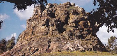
Piedra Pintada, Sandstone formation in Artigas Department, Uruguay.

Piedra Pintada is a sandstone formation that rises noticeably from the ground and displays red and green tones across its surface. The coloring comes from moss growth that covers the rock and highlights the natural layering of the stone.

The formation was first documented in 1883 when L. Villar carved an inscription into the sandstone surface. This early mark shows that people visited and noticed this structure over a century ago.

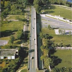
The rock sits within a park that has become a gathering place for people seeking outdoor activities in the northern region. Locals and travelers use the space to spend time in nature and explore the landscape.

The formation is accessible from two points along local roads that branch from Route 30. Wear sturdy footwear since the terrain is uneven and walking to reach the rock may be necessary.

The structure reveals different rock layers where basalt and sandstone meet, each resisting water erosion at different rates. At higher elevations, more resistant stone has been exposed through this gradual wearing process.

The community of curious travelers

AroundUs brings together thousands of curated places, local tips, and hidden gems, enriched daily by 60,000 contributors worldwide.

Start exploring
GPS coordinates
-30.51130,-56.37850
Latest update
December 12, 2025 09:00
Around this place
Mission Nuestra Señora de los Tres Reyes de Yapeyú
Argentina

Mission Nuestra Señora de los Tres Reyes de Yapeyú

123.2 km
Natural Protected Area Valle del Lunarejo
Uruguay

Natural Protected Area Valle del Lunarejo

87.6 km
Área de protección ambiental Rincón de Franquía
Uruguay

Área de protección ambiental Rincón de Franquía

123.9 km
Laguna de las Lavanderas
Uruguay

Laguna de las Lavanderas

140.2 km
Parque Estadual do Espinilho
Brazil

Parque Estadual do Espinilho

113.8 km
Altos del Arapey
Uruguay

Altos del Arapey

119.3 km
Cathedral of Tacuarembó
Uruguay

Cathedral of Tacuarembó

139 km
Ibirapuitã Biological Reserve
Brazil

Ibirapuitã Biological Reserve

86.9 km
Ibirapuitã Environmental Protection Area
Brazil

Ibirapuitã Environmental Protection Area

71.2 km
Museo de Artes Visuales de Tacuarembó
Uruguay

Museo de Artes Visuales de Tacuarembó

138.8 km
Sports museum in Tacuarembó
Uruguay

Sports museum in Tacuarembó

139.1 km
Parque Natural Regional Valle del Lunarejo
Uruguay

Parque Natural Regional Valle del Lunarejo

83.3 km
Museo de Geociencias
Uruguay

Museo de Geociencias

138.9 km
Parque 25 de Agosto
Uruguay

Parque 25 de Agosto

140.2 km
Museo del Indio y del Gaucho Washington Escobar
Uruguay

Museo del Indio y del Gaucho Washington Escobar

139.1 km
Estadio Goyenola
Uruguay

Estadio Goyenola

138.6 km
Antiga Casa do Marechal Bento Manuel Ribeiro de Almeida
Brazil

Antiga Casa do Marechal Bento Manuel Ribeiro de Almeida

98.7 km
Antigas Residências Em Alegrete
Brazil

Antigas Residências Em Alegrete

98.7 km
Museu Oswaldo Aranha
Brazil

Museu Oswaldo Aranha

98.9 km
Maara - Museu de Arqueologia e Artes
Brazil

Maara - Museu de Arqueologia e Artes

98.7 km
Jefatura de Policía, Artigas
Uruguay

Jefatura de Policía, Artigas

15 km
Centro de detención del Regimiento de Caballería No. 3
Uruguay

Centro de detención del Regimiento de Caballería No. 3

89.3 km
Museo Santa Rosa del Cuareim
Uruguay

Museo Santa Rosa del Cuareim

121 km
Museo Parroquial del Templo San Eugenio
Uruguay

Museo Parroquial del Templo San Eugenio

15.1 km
Centro de detención del Regimiento de Caballería No. 10
Uruguay

Centro de detención del Regimiento de Caballería No. 10

15.5 km
Templete Casa Natal del Gral. San Martín
Argentina

Templete Casa Natal del Gral. San Martín

123.1 km
Centro de detención del Regimiento de Caballería No. 10 - Escuadrón Bella Unión
Uruguay

Centro de detención del Regimiento de Caballería No. 10 - Escuadrón Bella Unión

120.9 km
Jefatura de policía de Artigas
Uruguay

Jefatura de policía de Artigas

15 km
Show the full map
Reviews
Share your experience

No review yet

Discussions
Start a discussion...

No discussion yet

« Piedra Pintada - Sandstone formation in Artigas Department, Uruguay » is provided by Around Us (aroundus.com). Images and texts are derived from Wikimedia project under a Creative Commons license. You are allowed to copy, distribute, and modify copies of this page, under the conditions set by the license, as long as this note is clearly visible.

Discover hidden gems everywhere you go!

From secret cafés to breathtaking viewpoints, skip the crowded tourist spots and find places that match your style. Our app makes it easy with voice search, smart filtering, route optimization, and insider tips from travelers worldwide. Download now for the complete mobile experience.

Around Us App Screenshot

A unique approach to discovering new places

Le Figaro

All the places worth exploring

France Info

A tailor-made excursion in just a few clicks

20 Minutes

Around Us
Travel Guide & Maps
Download

Send to your phone

QR Code
1

Open the camera app on your mobile.

2

Point at the QR code with your camera. A notification will appear.

3

Tap the notification to open the link.