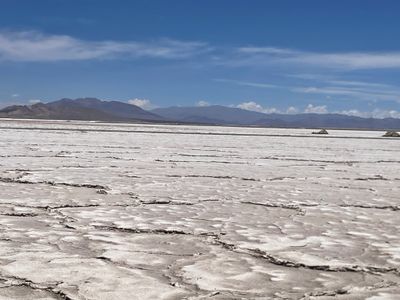
Salar del Hombre Muerto, Salt pan in Catamarca Province, Argentina.
Salar del Hombre Muerto is a vast salt flat in northwestern Catamarca that sits high in the mountains and stretches far across the landscape. The ground is covered in white salt deposits, with a few scattered ponds and water sources dotting the otherwise barren terrain.
Long ago, this area was covered by a large lake that gradually transformed into salt flats over many thousands of years. As the water slowly evaporated and geological processes continued, the white salt deposits formed and scattered water bodies remained.
The name refers to a local legend about a dead man, a story that still circulates among visitors today. Ancient communities around the area left traces of their presence in the surrounding hills, showing how important this region was to them.
You need a four-wheel drive vehicle to reach this place, as the roads are unpaved and run through remote mountain terrain. Bring plenty of water and supplies with you, since there are few facilities once you arrive.
Two rocky peninsulas divide the salt flat into distinct sections, each with slightly different geological features and salt compositions. These natural formations create separate landscape zones that feel almost like visiting two different places within the same location.
Location: Catamarca Province
Elevation above the sea: 3,968 m
Address: Salar del Hombre Muerto, Catamarca Province, Argentina
GPS coordinates: -25.35000,-67.07000
Latest update: December 7, 2025 10:05
Quebrada de las Conchas
149.8 km
Polvorilla viaduct
143.9 km
Galán
73.9 km
Quebrada de las Flechas
101.1 km
Quebrada del Toro
147.4 km
Tastil
150.4 km
Cuevas de Acsibi
102.1 km
Antofalla
84.9 km
Lastarria
146.5 km
Large Latin American Millimeter Array
142.2 km
Antofagasta de la Sierra
93.2 km
Aracar
138.3 km
Q&U Bolometric Interferometer for Cosmology
142.2 km
Cordón del Azufre
146.3 km
Vine and Wine Museum
136.3 km
Our Lady of Rosary Cathedral, Cafayate
136 km
Cerro Escorial
133.9 km
Caverna Puente del Diablo
110.1 km
Volcán Quehuar
120.9 km
Pucará de La Alumbrera
92 km
Archaeological Museum of Cachi
95 km
El Toro Viaduct
147.7 km
Museo Arqueológico Pío Pablo Díaz
95 km
Iglesia San Pedro Nolasco de los Molinos
78.8 km
Areas del Pueblo de Cachi
95 km
Areas del Pueblo de San Carlos
129.5 km
Iglesia de San José en Cachi
95 km
Areas del Pueblo de Molinos
78.8 kmVisited this place? Tap the stars to rate it and share your experience / photos with the community! Try now! You can cancel it anytime.
Discover hidden gems everywhere you go!
From secret cafés to breathtaking viewpoints, skip the crowded tourist spots and find places that match your style. Our app makes it easy with voice search, smart filtering, route optimization, and insider tips from travelers worldwide. Download now for the complete mobile experience.
A unique approach to discovering new places❞
— Le Figaro
All the places worth exploring❞
— France Info
A tailor-made excursion in just a few clicks❞
— 20 Minutes