Palmeira, Agricultural municipality in Paraná, Brazil.
Palmeira is a municipality in Paraná state in southern Brazil, situated at an elevation of 883 meters (2,897 feet) above sea level. The landscape is dominated by farmland and rural areas where agriculture forms the backbone of the local economy.
The municipality was established in 1897 after separating from a neighboring settlement, coinciding with the arrival of Russian-German immigrants in the area. These settlers shaped the region's development and established its agricultural identity.
The Witmarsum Colony, founded by Mennonites from German-speaking regions, has kept its farming traditions alive and continues to produce dairy products today. The community maintains its own way of life and customs that are visible in how people work and live in the area.
Two major highways pass through the area, connecting it with important cities in the region and making it easy for visitors to arrive and explore. The roads also serve as key routes for local commerce and travel.
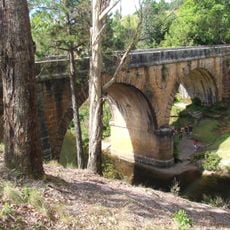
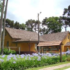
A historic stone bridge and a farm museum preserve memories of the region's architectural heritage and how people lived in earlier times. These sites reveal the craftsmanship and daily life of the early settlers.
Location: Paraná
Elevation above the sea: 883 m
Shares border with: Lapa, Porto Amazonas, São João do Triunfo, Balsa Nova, Campo Largo, Fernandes Pinheiro, Ponta Grossa, Teixeira Soares
Website: http://palmeira.pr.gov.br
GPS coordinates: -25.42889,-50.00583
Latest update: December 7, 2025 10:03
Vila Velha State Park
21.3 km
Colônia Witmarsum
18.5 km
Estádio Germano Krüger
38 km
Buraco do Padre
28.9 km
Campos Gerais National Park
42.1 km
Ponte do Rio dos Papagaios
24.2 km
Sede da Fazenda Cancela
18.6 km
Cineteatro Ópera
40.1 km
Museu Campos Gerais
40.1 km
Museu de Arqueologia de Ponta Grossa
37.3 km
Estação Paraná
40.2 km
Centro de Cultura Cidade de Ponta Grossa
40.2 km
Teatro Municipal Álvaro Augusto Cunha Rocha
37.4 km
Saudade Station
40.2 km
Faris Michaeli Municipal Library
40.2 km
Sítio Geológico - Estrias Glaciais de Witmarsum
18.5 km
Mansão Vila Hilda
40.7 km
Estações de Passageiros da Estrada de Ferro de Ponta Grossa
40.1 km
Capela de Santa Bárbara do Pitangui
43.5 km
Capela da Nossa Senhora da Conceição
29.9 km
Reservatório de Água de Ponta Grossa
41 km
Igreja de Nossa Senhora Imaculada Conceição
40.4 km
Igreja Nossa Senhora do Rosário (Ponta Grossa)
40.5 km
Estação Arte
40.1 km
Igreja Sagrado Coração de Jesus (Ponta Grossa)
40.4 km
Casa do Divino
40 km
Sede do Colégio São Luiz
40.4 km
Rua Augusto Ribas
40 kmVisited this place? Tap the stars to rate it and share your experience / photos with the community! Try now! You can cancel it anytime.
Discover hidden gems everywhere you go!
From secret cafés to breathtaking viewpoints, skip the crowded tourist spots and find places that match your style. Our app makes it easy with voice search, smart filtering, route optimization, and insider tips from travelers worldwide. Download now for the complete mobile experience.
A unique approach to discovering new places❞
— Le Figaro
All the places worth exploring❞
— France Info
A tailor-made excursion in just a few clicks❞
— 20 Minutes