Pico Agudo, Mountain peak in Japira, Brazil
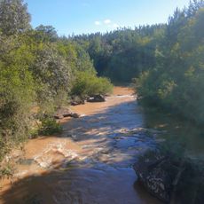
Pico Agudo is a mountain near Japira in southern Paraná state that rises to 960 meters above sea level and forms a prominent landmark in the landscape. The peak stands about 8 kilometers north of the town of Ibaiti and connects to regional transportation routes.
The peak was first documented in modern geographical surveys that used precise measurement techniques to establish its exact location. Systematic mapping of such landmarks has helped define the geography of southern Paraná over time.
Local sports enthusiasts and visitors gather at the peak between October and November for hang gliding and paragliding competitions that draw athletes from the region. These annual events shape the place as a meeting point for people who practice these aerial sports.
The mountain sits in a region well connected by road networks, especially via the BR-153 Transbrasiliana Highway that provides access routes. Visitors should prepare for mountainous conditions and variable weather depending on the season.
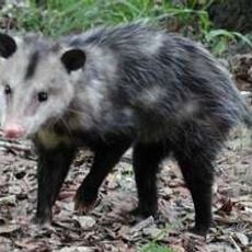
The summit serves as an observation point for studying the diverse plant and animal life found across southern Paraná. Its elevation and location make it valuable for ecological observation and nature research by visitors and local researchers.
GPS coordinates: -23.75243,-50.19482
Latest update: December 14, 2025 13:06
Telêmaco Borba Cable Car
75.5 km
Fazenda Velha
61.7 km
Alves Lima bridge
86.2 km
Cerrado State Park
71.6 km
Parque Ecológico Samuel Klabin
71.6 km
Piraí do Sul National Forest
85.5 km
Jaguariaíva River Canyon
71.6 km
Alegre River
68.5 km
Museu Casa do Colono de Tibagi
88.4 km
Museu Histórico Desembargador Edmundo Mercer Júnior
88 km
Teatro Municipal de Telêmaco Borba
78.1 km
Natural History Museum of Cornélio Procópio
79 km
Igreja Matriz da Paróquia Nossa Senhora dos Remédios de Tibagi
87.7 km
Parque Ecológico Dona Carmelita
88.5 km
Imóvel do antigo Grupo Escolar Telêmaco Borba e Reservatório de Água
87.8 km
Memorial do Garimpo
87.7 km
Cemetery of Harmonia
72.6 km
Estação Ferroviária de Jaguariaíva
74.4 km
Ponte Pênsil de Chavantes
86.2 km
Capela de Nossa Senhora do Perpétuo Socorro de Harmonia (Telêmaco Borba)
73.5 km
Teatro Municipal Tia Inália
87.7 km
Cemetery São Marcos (Telêmaco Borba)
77.8 km
Biblioteca Pública Municipal de Telêmaco Borba
78.1 km
Estádio Municipal Péricles Pacheco da Silva
78.6 km
Casa de Guataçara Borba Carneiro
87.8 km
Centro de Interpretação da Natureza Frans Krajcberg
71.5 km
Casa da Cidade Tibagi
87.7 km
Museu da Fauna e da Flora
71.6 kmVisited this place? Tap the stars to rate it and share your experience / photos with the community! Try now! You can cancel it anytime.
Discover hidden gems everywhere you go!
From secret cafés to breathtaking viewpoints, skip the crowded tourist spots and find places that match your style. Our app makes it easy with voice search, smart filtering, route optimization, and insider tips from travelers worldwide. Download now for the complete mobile experience.
A unique approach to discovering new places❞
— Le Figaro
All the places worth exploring❞
— France Info
A tailor-made excursion in just a few clicks❞
— 20 Minutes