Enable Location

We need your location to show you interesting places around you

Discover nearby places

Find interesting locations and hidden gems around you

Precise directions

Get accurate directions and distances to places

Your location is never shared with other users. It's only used when you tap the location button.

Log in to your account

Start exploring — it's free

Trusted by 62,057 travelers worldwide

Continue with Google
Continue with Apple
or

We will send you a code to connect

By continuing, you accept our Terms and Conditions and our Privacy Policy

Check your inbox

We've sent a pincode in your inbox. Please enter the code below.

Taquara, Administrative district in West Zone, Rio de Janeiro, Brazil.

Taquara is a neighborhood in Rio de Janeiro's West Zone with a mixed landscape of residential blocks, shops, and green spaces. The area stretches across hilly terrain and combines dense urban zones with protected nature reserves.

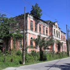
The area was largely rural until the mid-20th century and underwent rapid change as Rio de Janeiro expanded westward. This development led to the creation of a modern residential district while preserving natural areas.

For residents, this neighborhood serves as a place where city life meets green spaces that invite walks and leisure time. People use the parks and natural areas to escape the bustle of the urban surroundings.

The neighborhood is accessible by public transportation with several bus lines connecting residents and visitors. When exploring, keep in mind the terrain is hilly and comfortable shoes are important.

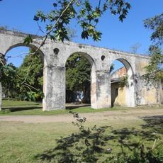
A large portion of this area borders the Pedra Branca protected forest, which is one of the region's last intact mountain rainforest complexes. This proximity to wilderness is unusual for an urban neighborhood and makes it a bridge between city nature and true wild space.

The community of curious travelers

AroundUs brings together thousands of curated places, local tips, and hidden gems, enriched daily by 60,000 contributors worldwide.

Start exploring
Location
Jacarepaguá
Location
Barra and Jacarepaguá
Shares border with
Pechincha
GPS coordinates
-22.92220,-43.38810
Latest update
December 23, 2025 03:42
« Taquara - Administrative district in West Zone, Rio de Janeiro, Brazil » is provided by Around Us (aroundus.com). Images and texts are derived from Wikimedia project under a Creative Commons license. You are allowed to copy, distribute, and modify copies of this page, under the conditions set by the license, as long as this note is clearly visible.

Discover hidden gems everywhere you go!

From secret cafés to breathtaking viewpoints, skip the crowded tourist spots and find places that match your style. Our app makes it easy with voice search, smart filtering, route optimization, and insider tips from travelers worldwide. Download now for the complete mobile experience.

Around Us App Screenshot

A unique approach to discovering new places

Le Figaro

All the places worth exploring

France Info

A tailor-made excursion in just a few clicks

20 Minutes

Around Us
Travel Guide & Maps
Download

Send to your phone

QR Code
1

Open the camera app on your mobile.

2

Point at the QR code with your camera. A notification will appear.

3

Tap the notification to open the link.