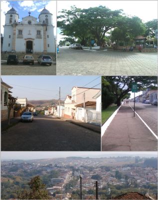
Andrelândia, Administrative municipality in southern Minas Gerais, Brazil.
Andrelândia is a municipality in southern Minas Gerais that spreads across hilly terrain set between mountains and valleys. It is home to around 12,500 people in the South Minas Gerais mesoregion.
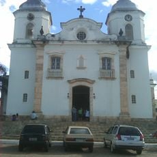
The settlement began in the 1700s when gold mining activities attracted people to the area and a small chapel was built. This chapel became the foundation around which the municipality gradually developed.
Religious traditions shape daily life here, with annual celebrations like the Feast of Saint Sebastian and Corpus Christi bringing communities together throughout the year.
The municipality's website provides access to public services and administrative information for residents and visitors. Digital platforms make it straightforward to find government information and local guidance.
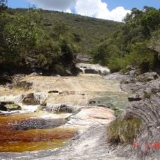
Rock paintings in the Serra de Santo Antonio hills show evidence of human presence thousands of years before the municipality was founded. These ancient artworks reveal a much older history of settlement in this region.
Location: Minas Gerais
Elevation above the sea: 1,046 m
Shares border with: São Vicente de Minas, Madre de Deus de Minas, Seritinga, Serranos, Bom Jardim de Minas, Liberdade, Lima Duarte, Santana do Garambéu, Piedade do Rio Grande, Arantina
Website: http://andrelandia.mg.gov.br
GPS coordinates: -21.74000,-44.30889
Latest update: December 25, 2025 12:46
Ibitipoca State Park
42.4 km
Igreja Matriz de Andrelândia
31 m
Igreja Nossa Senhora do Rosário
520 mMirante do Parque
43 kmMirante do Parque
43.1 kmPonte de Pedra
43 kmEstátuas gigantes
43.9 kmGruta dos Gnomos
43 kmMirante do Gavião
43 kmScenic viewpoint
34.4 kmScenic viewpoint
32.8 kmScenic viewpoint
31.5 kmScenic viewpoint
38.6 kmScenic viewpoint
38.1 kmCachoeira dos Macacos
43 kmMirante do Parque
43 kmLago das Miragens
43 kmMirante da Prainha
43.1 kmCorte Fundo
30.9 kmMirante das Abelhas
43.7 kmCachoeira do Índio
39.6 kmCachoeira dos Anjos
38.9 kmCachoeira da Estiva
40 kmCachoeira do Azeite
24.8 kmRaia das Ninfas
43 kmPoço Dourado
43 kmCachoeira dos macacos
43 kmDucha
43.1 kmVisited this place? Tap the stars to rate it and share your experience / photos with the community! Try now! You can cancel it anytime.
Discover hidden gems everywhere you go!
From secret cafés to breathtaking viewpoints, skip the crowded tourist spots and find places that match your style. Our app makes it easy with voice search, smart filtering, route optimization, and insider tips from travelers worldwide. Download now for the complete mobile experience.
A unique approach to discovering new places❞
— Le Figaro
All the places worth exploring❞
— France Info
A tailor-made excursion in just a few clicks❞
— 20 Minutes