Ibitipoca State Park

Log in to your account

AroundUs is a community-driven map of interesting places, built by curious explorers like you. It grows with every review, story, and photo you share.
Connect to save your favorite spots, contribute locations, and create personalized routes.
By continuing, you accept our Terms and Conditions and our Privacy Policy

Ibitipoca State Park

Add to collection
Map
Suggest a change
Share

Ibitipoca State Park, State park in Lima Duarte, Minas Gerais, Brazil.

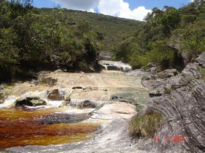
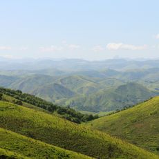
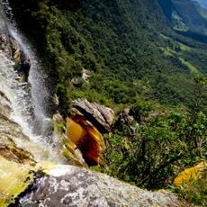
Ibitipoca State Park covers around 1500 hectares of mountainous terrain in the Serra do Ibitipoca range, featuring limestone caves, several waterfalls, cold natural pools, and shifting vegetation zones. The landscape alternates between open ridges with sweeping views and forested sections, with rocky outcrops and stream channels defining the paths visitors follow.

The park was established in 1973 to protect the mountainous landscape and its ecosystems. The name comes from the Tupi-Guarani language and refers to the mountain's exposure to frequent lightning strikes, a defining feature of this exposed ridge environment.

The park's three main trails represent different ways visitors experience the landscape, with each route revealing distinct natural formations and seasonal changes. Local guides often share stories about how the mountain has shaped the region's identity over generations.

The best time to visit is during cooler months when trails are dry and visibility is good. Wear sturdy shoes and bring plenty of water, as the elevation and steep sections require a steady pace and good conditioning.

The Janela do Céu viewpoint sits at 1784 meters elevation and offers a rare vantage point overlooking the watershed boundary between two major river basins. On clear days, visitors can see where the landscape's water flow divides into separate systems heading toward different regions.

Location: Lima Duarte

Inception: 1973

Elevation above the sea: 1,350 m

Email: peibitipoca@meioambiente.gov.mg.gov.br

Website: http://ief.mg.gov.br/component/content/192?task=view

GPS coordinates: -21.71667,-43.90000

Latest update: December 6, 2025 16:03

Photos
Natural spots and local places in Brazil

Brazil has natural areas and local sites away from major cities. The landscape ranges from waterfalls and caves to coastal regions and mountains. National parks hold sand formations, lagoons, and coral reefs. Cultural places include traditional villages and historical sites. Visitors can explore...

Natural sites and cultural places in Southeast Brazil

Southeast Brazil spans the states of São Paulo, Rio de Janeiro, Minas Gerais and Espírito Santo, offering coastal landscapes, mountain villages, caves and waterfalls. The region preserves colonial-era trails, grottos with underground formations and islands with light visitor traffic. Sites show how...

Reviews

Visited this place? Tap the stars to rate it and share your experience / photos with the community! Try now! You can cancel it anytime.

« Ibitipoca State Park - State park in Lima Duarte, Minas Gerais, Brazil » is provided by Around Us (aroundus.com). Images and texts are derived from Wikimedia project under a Creative Commons license. You are allowed to copy, distribute, and modify copies of this page, under the conditions set by the license, as long as this note is clearly visible.

Discover hidden gems everywhere you go!

From secret cafés to breathtaking viewpoints, skip the crowded tourist spots and find places that match your style. Our app makes it easy with voice search, smart filtering, route optimization, and insider tips from travelers worldwide. Download now for the complete mobile experience.

Around Us App Screenshot

A unique approach to discovering new places

Le Figaro

All the places worth exploring

France Info

A tailor-made excursion in just a few clicks

20 Minutes