Enable Location

We need your location to show you interesting places around you

Discover nearby places

Find interesting locations and hidden gems around you

Precise directions

Get accurate directions and distances to places

Your location is never shared with other users. It's only used when you tap the location button.

Barra do Garças

Log in to your account

Start exploring — it's free

Trusted by 62,832 travelers worldwide

Continue with Google
Continue with Apple
or

We will send you a code to connect

By continuing, you accept our Terms and Conditions and our Privacy Policy

Check your inbox

We've sent a pincode in your inbox. Please enter the code below.

Barra do Garças, Administrative center in Mato Grosso, Brazil.

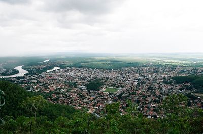
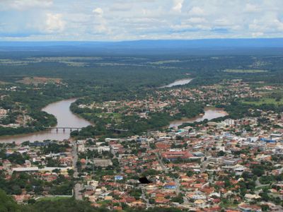
Barra do Garças sits where the Garças and Araguaia rivers meet, spreading across a large area with varied landscapes throughout. The city has an airport, several water parks, and natural springs that serve both visitors and residents.

The settlement grew from a small river community and became an official municipality in 1948, marking a new phase of local development. This founding enabled growth and improved infrastructure that continues to shape the region today.

The annual Caju Festival showcases local traditions through music, regional food, and gatherings in the Voadeira area that shape community life. These celebrations bring people together and show how important shared meals and neighborhood connection are in daily life here.

The city has an airport for larger trips and several water parks for cooling off on hot days. Natural springs are scattered throughout the area, so a local guide or map helps find the best spots to visit.

The city is known for a special site called Discoporto, designed as a UFO landing spot that reflects local interest in extraterrestrial phenomena. This unusual place attracts curious visitors looking to explore something unexpected.

The community of curious travelers

AroundUs brings together thousands of curated places, local tips, and hidden gems, enriched daily by 60,000 contributors worldwide.

Start exploring
Location
Elevation above the sea
318 m
Shares border with
Araguaiana, Nova Xavantina, Aragarças, General Carneiro, Novo São Joaquim, Pontal do Araguaia
GPS coordinates
-15.89000,-52.25694
Latest update
December 17, 2025 07:39
« Barra do Garças - Administrative center in Mato Grosso, Brazil » is provided by Around Us (aroundus.com). Images and texts are derived from Wikimedia project under a Creative Commons license. You are allowed to copy, distribute, and modify copies of this page, under the conditions set by the license, as long as this note is clearly visible.

Discover hidden gems everywhere you go!

From secret cafés to breathtaking viewpoints, skip the crowded tourist spots and find places that match your style. Our app makes it easy with voice search, smart filtering, route optimization, and insider tips from travelers worldwide. Download now for the complete mobile experience.

Around Us App Screenshot

A unique approach to discovering new places

Le Figaro

All the places worth exploring

France Info

A tailor-made excursion in just a few clicks

20 Minutes

Around Us
Travel Guide & Maps
Download

Send to your phone

QR Code
1

Open the camera app on your mobile.

2

Point at the QR code with your camera. A notification will appear.

3

Tap the notification to open the link.