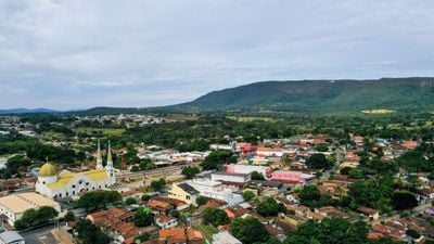
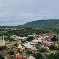
Jaraguá, Municipality in central Goiás, Brazil
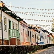
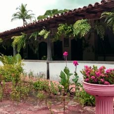
Jaraguá is a municipality in central Goiás that covers substantial land in the region's interior. The settlement includes residential areas, a religious center at the chiesa heart, and commercial zones developed around trade routes.
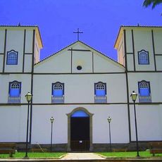
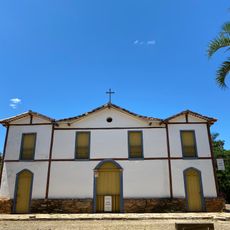
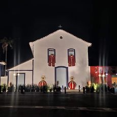
The settlement began in the early 1700s when prospectors discovered a spring called Córrego de Jaraguá and established a community there. The church was built in 1748 and marked the formation of a permanent center for religious and civic life.
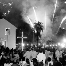
The Nossa Senhora da Penha church shapes the center with its traditional style and shows how religious structures influence daily community life. It serves as a gathering point and landmark for residents.
The area is reachable via the major BR-153 highway connecting Belém and Brasília, which links to larger cities and makes travel straightforward. Visitors will find it easy to arrive by car or bus.
Since the 1970s the city transformed into a major clothing production center with factories spread throughout its streets and surrounding areas. This industrial shift completely reshaped how the place looks and functions today.
Location: Goiás
Elevation above the sea: 626 m
Shares border with: Pirenópolis, Goianésia, Itaguari, Itaguaru, Jesúpolis, Rianápolis, Santa Isabel, Santa Rosa de Goiás, São Francisco de Goiás, Taquaral de Goiás, Uruana
GPS coordinates: -15.75694,-49.33389
Latest update: December 7, 2025 10:02
Historic Centre of the Town of Goiás
87.8 km
Parish Church of Our Lady of the Rosary
41.6 km
Museu Casa de Cora Coralina
88.5 km
Count of Arcos Palace
88.6 km
Pirineus State Park
52.1 km
Museu das Bandeiras
88.7 km
Church of Our Lady of the Good Death
88.6 km
Historic center of Pirenópolis
41.5 km
Church of Our Lord of Bonfim
42.2 km
Church of Our Lady of Carmo
41.4 km
House of the Babilónia Estate
39.3 km
Parque Estadual da Serra de Jaraguá
4.7 km
Casa de Câmara e Cadeia
41.5 km
Museum of Sacred Art
88.5 km
Capela Nossa Senhora da Penha de França
59.4 km
Church of Saint John the Baptist
84.1 km
Largo do Chafariz
88.6 km
Igreja de Nossa Senhora da Conceição
357 m
Conjunto arquitetônico e urbanístico da Rua João Pessoa, antiga da Fundição
88.6 km
Casa de Câmara e Cadeia
88.6 km
Igreja de Nossa Senhora do Rosário
852 m
Cachoeira das Araras
32.5 km
Church of Our Lady of the Abbey
88.7 km
Conjunto Arquitetônico e Urbanístico da Rua Sebastião Fleury Curado
88.6 km
Roman Catholic Cathedral of Goiás
88.6 km
Cachoeira do Abade
48.9 km
Fazenda Gleba Vargem I Private Natural Heritage Reserve
45.9 km
Cinemais Anápolis
75.3 kmVisited this place? Tap the stars to rate it and share your experience / photos with the community! Try now! You can cancel it anytime.
Discover hidden gems everywhere you go!
From secret cafés to breathtaking viewpoints, skip the crowded tourist spots and find places that match your style. Our app makes it easy with voice search, smart filtering, route optimization, and insider tips from travelers worldwide. Download now for the complete mobile experience.
A unique approach to discovering new places❞
— Le Figaro
All the places worth exploring❞
— France Info
A tailor-made excursion in just a few clicks❞
— 20 Minutes