Enable Location

We need your location to show you interesting places around you

Discover nearby places

Find interesting locations and hidden gems around you

Precise directions

Get accurate directions and distances to places

Your location is never shared with other users. It's only used when you tap the location button.

Macaúbas

Log in to your account

Start exploring — it's free

Trusted by 61,997 travelers worldwide

Continue with Google
Continue with Apple
or

We will send you a code to connect

By continuing, you accept our Terms and Conditions and our Privacy Policy

Check your inbox

We've sent a pincode in your inbox. Please enter the code below.

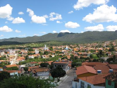
Macaúbas, Municipality in Chapada Diamantina, Bahia, Brazil

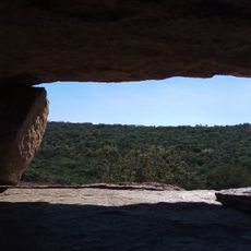
Macaúbas is a municipality in the Chapada Diamantina region, a highland area in northeastern Brazil characterized by varied terrain and natural features. The location sits at altitude and includes rivers, valleys, and diverse vegetation across its territory.

The settlement began in the mid-1600s when Portuguese colonists built a chapel dedicated to Our Lady of the Immaculate Conception. This religious foundation became the center around which the place grew and developed over time.

The Tupinaés people, part of the Tupinambás group, were the first to settle in the region and left marks on local traditions and customs. Their presence shaped the character of the place and remains visible in place names and everyday practices.

The place sits in a hilly region with varying terrain, so comfortable shoes and reasonable fitness help when exploring. The best time to visit is during drier months when paths and roads are more accessible.

The name Macaúbas comes from indigenous language and refers to a palm tree species that once grew abundantly throughout the region. This tree was economically and culturally important to early inhabitants and continues to shape the place's identity.

The community of curious travelers

AroundUs brings together thousands of curated places, local tips, and hidden gems, enriched daily by 60,000 contributors worldwide.

Start exploring
Location
Elevation above the sea
716 m
Shares border with
Paratinga, Boquira, Ibipitanga, Bom Jesus da Lapa, Botuporã, Caturama, Igaporã, Riacho de Santana, Rio do Pires, Tanque Novo
GPS coordinates
-13.01889,-42.69889
Latest update
December 20, 2025 14:23
« Macaúbas - Municipality in Chapada Diamantina, Bahia, Brazil » is provided by Around Us (aroundus.com). Images and texts are derived from Wikimedia project under a Creative Commons license. You are allowed to copy, distribute, and modify copies of this page, under the conditions set by the license, as long as this note is clearly visible.

Discover hidden gems everywhere you go!

From secret cafés to breathtaking viewpoints, skip the crowded tourist spots and find places that match your style. Our app makes it easy with voice search, smart filtering, route optimization, and insider tips from travelers worldwide. Download now for the complete mobile experience.

Around Us App Screenshot

A unique approach to discovering new places

Le Figaro

All the places worth exploring

France Info

A tailor-made excursion in just a few clicks

20 Minutes

Around Us
Travel Guide & Maps
Download

Send to your phone

QR Code
1

Open the camera app on your mobile.

2

Point at the QR code with your camera. A notification will appear.

3

Tap the notification to open the link.