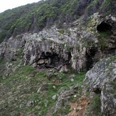
Bloukrans, cliff in Western Cape, South Africa; geonames ID = 1018429
Location: Western Cape
Elevation above the sea: 7 m
GPS coordinates: -34.45833,20.75972
Latest update: November 20, 2025 07:51
Blombos Cave
42.4 km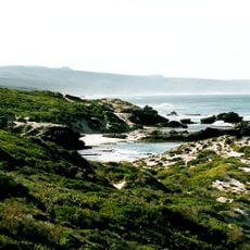
De Hoop Nature Reserve
14.5 km
De Hoop Marine Protected Area
4.7 km
Agulhas Muds Marine Protected Area
50.9 km
Kaap Infantavuurtoring
8.1 km
Langklipkrans
53.4 km
Dassiekrans
52.4 km
Grootjongensfonteinstrand
52.7 km
Blombosstrand
41.4 km
Keizersgat
7 km
Potbergstrand
20.6 km
Ramskraal
37.9 km
Lynkrans
9.9 km
Kadiekop
6.1 km
Maalhoek
34.7 km
Hamerkop
9.3 km
Scenic viewpoint
52.5 km
Drupkelder Waterfall
53.1 km
Scenic viewpoint
52.3 km
Scenic viewpoint
52 km
Scenic viewpoint
50.6 km
Scenic viewpoint
53.1 km
The Poimt
10.4 km
Viewing Deck
51.6 km
Scenic viewpoint
53.3 km
Ruins
50.9 km
Waterfall
51.6 km
Waterfall
53.3 kmReviews
Visited this place? Tap the stars to rate it and share your experience / photos with the community! Try now! You can cancel it anytime.
Discover hidden gems everywhere you go!
From secret cafés to breathtaking viewpoints, skip the crowded tourist spots and find places that match your style. Our app makes it easy with voice search, smart filtering, route optimization, and insider tips from travelers worldwide. Download now for the complete mobile experience.

A unique approach to discovering new places❞
— Le Figaro
All the places worth exploring❞
— France Info
A tailor-made excursion in just a few clicks❞
— 20 Minutes