Gorongosa National Park

Log in to your account

AroundUs is a community-driven map of interesting places, built by curious explorers like you. It grows with every review, story, and photo you share.
Connect to save your favorite spots, contribute locations, and create personalized routes.
By continuing, you accept our Terms and Conditions and our Privacy Policy

Gorongosa National Park

Add to collection
Map
Suggest a change
Share

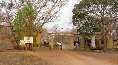
Gorongosa National Park, National park in Sofala Province, Mozambique.

Gorongosa National Park is a protected reserve in Sofala Province, Mozambique, at the southern end of the Great Rift Valley. The area includes floodplains, grasslands, and forested hills that stretch along rivers which overflow during the rainy season.

The reserve was established as a formal national park in 1960, after the area had first been protected in 1921. During the civil war from 1977 to 1992, wildlife suffered heavy losses, and a collaboration between government and private organizations from 2008 onward led to the reintroduction of many species.

The name comes from the nearby Mount Gorongosa, which local communities regard as a sacred site with spiritual importance. Visitors often notice how villages surrounding the reserve participate in educational and health initiatives linked to conservation efforts.

Visitors can explore the area with professional guides on foot or by vehicle, best during the dry months from May to October. The reserve offers accommodations in different categories and camping options in selected zones.

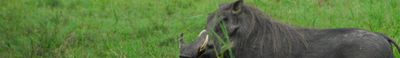
The reintroduction program brought over 200 elephants and numerous lions, wild dogs, and other mammals back to the reserve. Research labs on site collect data on climate, soil, and animal movements and make them available for scientific projects worldwide.

Location: Sofala

Inception: July 23, 1960

Website: https://gorongosa.net

GPS coordinates: -18.76600,34.50000

Latest update: December 5, 2025 22:26

Photos
Photo spots in Mozambique

Mozambique stretches along the Indian Ocean coast for 1,500 miles (2,400 kilometers) and presents photographers with diverse subjects. The coastal region includes archipelagos such as Bazaruto and Quirimbas with white sand beaches and coral reefs. Along the shore sit historic structures like Macuti...

Reviews

Visited this place? Tap the stars to rate it and share your experience / photos with the community! Try now! You can cancel it anytime.

« Gorongosa National Park - National park in Sofala Province, Mozambique » is provided by Around Us (aroundus.com). Images and texts are derived from Wikimedia project under a Creative Commons license. You are allowed to copy, distribute, and modify copies of this page, under the conditions set by the license, as long as this note is clearly visible.

Discover hidden gems everywhere you go!

From secret cafés to breathtaking viewpoints, skip the crowded tourist spots and find places that match your style. Our app makes it easy with voice search, smart filtering, route optimization, and insider tips from travelers worldwide. Download now for the complete mobile experience.

Around Us App Screenshot

A unique approach to discovering new places

Le Figaro

All the places worth exploring

France Info

A tailor-made excursion in just a few clicks

20 Minutes