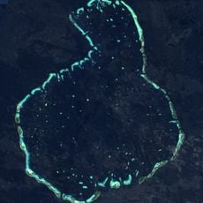
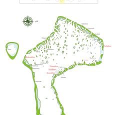
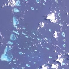
Great Chagos Bank, Atoll structure in Chagos Archipelago, Indian Ocean.
The Great Chagos Bank is a vast underwater plateau with a rim of small islands along its western edge and shallow reefs emerging from the seafloor. Several islands including Danger Island, Eagle Island, and Sea Cow Island rise from the shallow waters, along with Nelson Island positioned separately in the north.
The bank was first comprehensively surveyed by Commander Robert Moresby in 1837, producing nautical charts that served as standard references for navigation for many decades. Those early surveys helped mariners understand where dangerous shallow waters and safe anchorages were located.
The area functions as a marine reserve managed by the British Indian Ocean Territory, protecting delicate ecosystems that have adapted to the shallow tropical waters. Visitors and researchers value this place for its coral formations and the fish and seabirds that depend on these shallow habitats.
Access to the area is limited mostly to specialized expeditions and research activities because of its remote location in the Indian Ocean. The best time to visit is during drier months when the sea is calmer and underwater visibility improves.
This is the world's largest atoll structure, yet almost entirely hidden beneath the waves with only a few square kilometers of land visible above water. Most people do not realize that the small island network is actually the tip of a massive underwater basin.
The community of curious travelers
AroundUs brings together thousands of curated places, local tips, and hidden gems, enriched daily by 60,000 contributors worldwide.