Watheroo National Park, Nature reserve in Shire of Moora, Australia.
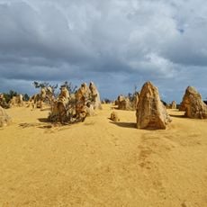
Watheroo National Park is a nature reserve in the Shire of Moora region that covers approximately 60,000 hectares. The landscape features low heath vegetation, Banksia woodlands, and Mallee scrub that extends down to the banks of the Moore River.
The park takes its name from an Indigenous Australian word for a nearby spring, also used for the town about 10 km to the east. In 2010 the Environmental Protection Authority of Western Australia approved a seismic survey of the Warro gas field beneath the park, and Latent Petroleum was permitted to drive over vegetation to conduct it.
The park's name comes from the Indigenous Australian name of a nearby spring; the same name was later given to the town about ten kilometres east of the park. The park lies west of Midlands Road, between Badgingarra and Dalwallinu, and is otherwise surrounded by farmland.
The park lies west of Midlands Road between Badgingarra and Dalwallinu, about 200 km north of Perth and 10 km west of Watheroo, and gravel tracks reach it from all directions. Wildflowers bloom between July and November. The park is surrounded by farmland, with Low Creek along its eastern edge.
In 2010 Western Australia's Environmental Protection Authority approved a seismic survey of the Warro gas field beneath the park; Latent Petroleum was allowed to drive vehicles over the vegetation to conduct it. The park's name comes from an Indigenous name for a nearby spring, also used by the town to the east.
The community of curious travelers
AroundUs brings together thousands of curated places, local tips, and hidden gems, enriched daily by 94,794 contributors worldwide.