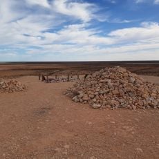
Zuytdorp Cliffs, Limestone cliffs in Shark Bay, Australia.
Zuytdorp Cliffs is a line of Pleistocene limestone sea cliffs running about 150 kilometres along the Indian Ocean coast of Western Australia, from south of the Murchison River mouth at Kalbarri to Pepper Point south of Steep Point. The cliffs are formed of Tamala Limestone, cemented ancient calcareous sand dunes, and reach 250 metres above the sea near Womerangee Hill. Their straight edge is thought to follow a major offshore fault line.
The cliffs take their name from the Zuytdorp, a Dutch East India Company trading ship wrecked against them in 1712. The vessel was bound for Batavia with silver and trade goods; its loss left survivors and a wreck site that later gave the cliffs their name. The site lies between Kalbarri and Pepper Point, south of Steep Point.
The cliffs take their name from the Zuytdorp, a Dutch East India Company trading ship wrecked against them in 1712. The vessel's loss left its mark on the coast, and the surrounding waters are now part of the Shark Bay area, where visitors can see the wreck site marked in local maritime records.
This location requires a four-wheel-drive vehicle and travel over unpaved roads, so visitors should bring adequate water and supplies. The region has limited facilities, making good planning and preparation essential before visiting.
The cliffs' straight edge is thought to follow a major fault line just offshore, not the shape of the limestone itself. The rock is Tamala Limestone, Pleistocene dunes cemented during ice-age low sea levels. Near Womerangee Hill the top reaches 250 metres, the highest point along the 150-kilometre run.
The community of curious travelers
AroundUs brings together thousands of curated places, local tips, and hidden gems, enriched daily by 94,563 contributors worldwide.