Maungatua, Mountain summit near Dunedin, New Zealand
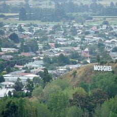
Maungatua is a prominent ridge rising 895 metres above the Taieri River floodplain, directly west of Dunedin's airport at Momona. It is visible from much of Dunedin's urban area, 35 kilometres away, and from as far south as the outskirts of Balclutha, 65 kilometres to the southwest. Lake Mahinerangi lies on its western side.
The name Maungatua refers to an ancestral chief who arrived on the Āraiteuru migratory waka, according to Ngāi Tahu tradition. The mountain is also spelled Mauka Atua by Ngāi Tahu in Otago, reflecting the southern Māori pronunciation. It rises 895 metres above the Taieri Plains, west of Dunedin's airport.
The name Maungatua comes from Māori language and means 'Hill of the Spirits', with the Ngāi Tahu people also using the alternative spelling Mauka Atua. This place name reflects the deep spiritual connection that local indigenous communities maintain with this landscape.
The summit is reached by unmarked routes; no formed tracks or facilities exist. Access is via the Waipori Gorge or from the Momona side, crossing private farmland, so permission is needed. The climb is steep and exposed, with boggy ground at the top. Lake Mahinerangi lies on the western side.
The only naturally occurring kāmahi in the Dunedin area grow in Mill Creek on the southern slopes of Maungatua. Sundews, carnivorous plants, grow in the swamps at the summit, and glowworms live in mānuka trees at the base of the ridge.
The community of curious travelers
AroundUs brings together thousands of curated places, local tips, and hidden gems, enriched daily by 93,409 contributors worldwide.