Chest opened
+${chestReward.xp} XP
Explorer
NOUVEAU ×${chestReward.collectible.quantity}
tapez pour fermer

See the monuments around you in AR Open chests in the app

Around Us is built for your phone — point your camera at the streets and discover the monuments and places around you in augmented reality. Around Us is built for your phone — chests unlock when you walk, explore and capture nearby places.

•

Enable Location

We need your location to show you interesting places around you

Discover nearby places

Find interesting locations and hidden gems around you

Precise directions

Get accurate directions and distances to places

Your location is never shared with other users. It's only used when you tap the location button.

Hoopers Inlet

Log in to your account

Start exploring — it's free

Trusted by 94,124 travelers worldwide

Continue with Google
Continue with Apple
or

We will send you a code to connect

By continuing, you accept our Terms and Conditions and our Privacy Policy

Check your inbox

We've sent a pincode in your inbox. Please enter the code below.

Hoopers Inlet

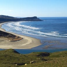
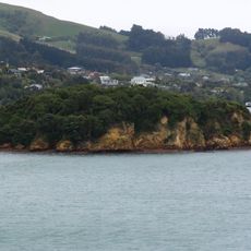
Hoopers Inlet, Coastal inlet in Otago Peninsula, New Zealand.

Hoopers Inlet is one of two large inlets on the Pacific coast of the Otago Peninsula, 15 km east of central Dunedin and 2 km south of Portobello. It is shallow, turning mostly to sand and mud flats at low tide, and its mouth is narrowed by a large spit whose seaward side forms Allans Beach. Behind the beach lie wetland and swamp.

The name's origin is uncertain: an early settler family called Hooper lived nearby, yet the name appears on charts made before their arrival. A. W. Reed suggested it is a corruption of "Cooper's Inlet", after Daniel Cooper, captain of the Unity, a ship active during the peninsula's sealing years. The inlet lay on a traditional Māori shellfish-gathering route from Otakou to what is now St Clair.

The Māori name Puke-tu-roto can mean either "hills standing around a lake" or "hills standing inland". The inlet lay on a traditional Māori route for collecting shellfish that ran from Otakou to what is now St. Clair.

The area is accessible by road from Portobello and Dunedin, with a network of walking trails throughout the surroundings. Visiting at low tide offers the best views of the exposed flats and the most comfortable walking conditions.

The wetlands behind Allans Beach create habitats for numerous bird species and specialized plant communities found nowhere else nearby. This area often goes unnoticed by casual visitors but rewards those who explore it with excellent birdwatching opportunities.

The community of curious travelers

AroundUs brings together thousands of curated places, local tips, and hidden gems, enriched daily by 94,124 contributors worldwide.

Start exploring
Location
GPS coordinates
-45.86400,170.67100
Latest update
October 31, 2026 11:27
Reviews
Share your experience

No review yet

Discussions
Start a discussion...

No discussion yet

« Hoopers Inlet - Coastal inlet in Otago Peninsula, New Zealand » is provided by Around Us (aroundus.com). Images and texts are derived from Wikimedia project under a Creative Commons license. You are allowed to copy, distribute, and modify copies of this page, under the conditions set by the license, as long as this note is clearly visible.

Discover hidden gems everywhere you go!

From secret cafés to breathtaking viewpoints, skip the crowded tourist spots and find places that match your style. Our app makes it easy with voice search, smart filtering, route optimization, and insider tips from travelers worldwide. Download now for the complete mobile experience.
Around Us App Screenshot
❝

A unique approach to discovering new places❞

— Le Figaro

❝

All the places worth exploring❞

— France Info

❝

A tailor-made excursion in just a few clicks❞

— 20 Minutes

Around Us
Travel Guide & Maps
Download

Send to your phone

QR Code
1

Open the camera app on your mobile.

2

Point at the QR code with your camera. A notification will appear.

3

Tap the notification to open the link.