Mount Richmond Forest Park, Forest park in Marlborough District, New Zealand.
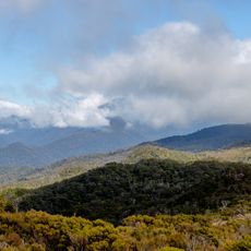
Mount Richmond Forest Park is a large forest reserve spanning multiple districts with native forests, river systems, and mountain ranges, where Mount Richmond itself rises to about 1,760 meters as the highest peak. The landscape features diverse ecosystems ranging from thick forest to open alpine zones at higher elevations.
The park was formally established in 1977, incorporating forest and mountain terrain that had long been traversed and used by various communities and explorers. A tragic plane crash in 1942 on Mount Richmond's slopes marked one of the earliest aviation accidents involving civilians in New Zealand.
The park's name comes from Mount Richmond, its highest point at 1,760 metres. Māori ancestors used routes through this land and worked argillite deposits to make traditional tools. Te Araroa trail now follows some of the park's 250 kilometres of tracks and huts.
The reserve is managed by the Department of Conservation with an extensive network of walking tracks and basic shelters suitable for different fitness levels and day trips. Visitors should prepare for changeable mountain weather and steep terrain by bringing proper gear and navigation tools.
Lake Chalice, the only lake in the park, was dammed by an earthquake about 2,000 years ago. It lies within the Richmond Range, which the park follows for roughly 85 km, and the Wairau River drains the southern side of the park toward Blenheim.
The community of curious travelers
AroundUs brings together thousands of curated places, local tips, and hidden gems, enriched daily by 93,930 contributors worldwide.