Fort Philip, Military fort in Millers Point, Australia
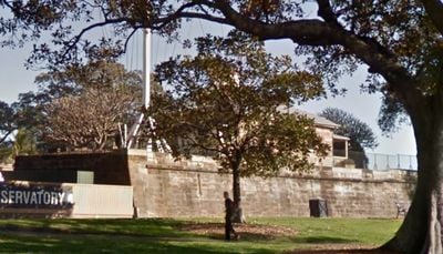
Fort Philip is a stone fortification built on Observatory Hill to defend Sydney Harbour and monitor approaches to the colonial settlement. The eastern rampart remains the only original section visible today, supported by explanatory panels documenting the site's military role and later transformation.
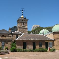
Governor John Hunter commissioned the fort in 1804 to defend against French threats and suppress potential convict rebellions within the colony. The site later transitioned to scientific use when the Sydney Observatory was established, marking the end of its military function.
The site represents a shift from military defense to scientific inquiry, marking how the colonial settlement transformed its relationship with land and knowledge. This transition reflected the growing importance of astronomy in navigation and timekeeping for ships in the harbor.
The site is best reached on foot and sits near other heritage buildings on Observatory Hill, making it easy to combine visits to several locations in one walk. Access is available year-round, though weather conditions may affect visibility and the condition of the exposed remains.
A signal station built in 1847 transmitted messages to harbor vessels using an advanced flag communication system that preceded electronic telegaphy. This ingenious method allowed rapid information exchange across the water and represented an important innovation in maritime communication for the era.
The community of curious travelers
AroundUs brings together thousands of curated places, local tips, and hidden gems, enriched daily by 60,000 contributors worldwide.