Stockton Beach, Coastal beach in Stockton, New South Wales
Stockton Beach is a long stretch of coast in New South Wales with pale sand and high dunes that run for about 32 kilometers between Newcastle and Port Stephens. The dunes reach over 30 meters (100 feet) in some places and form a rolling landscape that extends from the flat beach into the interior.
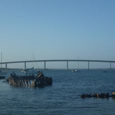
Shipwrecks have marked Stockton Beach for about 200 years, especially from the late 19th century. The steamer Uralla, 46.4 m long, ran aground in a gale on 14 June 1928 about 9 km down the beach from Anna Bay; it was refloated, drifted back and broke up, and its remains appear at low tide. The Norwegian bulk carrier MV Sygna, of 53,000 t, grounded in a major storm on 26 May 1974.
The Worimi people lived along this coast before European settlement, and their middens, up to 12,000 years old and made mainly of pipi and whelk shells, can be seen at many points along the beach. A midden conservation area where beach driving is not permitted protects these sites. The beach lies largely within the Worimi conservation lands, managed by the NSW National Parks & Wildlife Service.
You can reach the beach through access points at Lavis Lane and Anna Bay, with four-wheel drive vehicles needing a permit to drive on certain sections. Most visitors come on foot or park at the edge and walk from there, as the terrain is often soft and uneven.
The dunes move constantly through wind and waves, sometimes uncovering old objects or remains that have been hidden for decades. You occasionally find pieces of shipwrecks or other traces from the past that come back to the surface.
The community of curious travelers
AroundUs brings together thousands of curated places, local tips, and hidden gems, enriched daily by 93,539 contributors worldwide.