Cape Palmerston National Park, National park along coastal Queensland, Australia
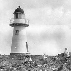
Cape Palmerston National Park protects 7,160 ha of rocky headlands, sand dunes, swamps and rainforest on 28 km of coastline in the Mackay Region, with Mount Funnel rising 344 m. Eucalyptus woodland covers the ridges, myrtle heath fills the narrow valleys, and mangroves line the shore.
Cape Palmerston was named by Captain James Cook in 1770 after Viscount Palmerston, a Lord Commissioner of the Admiralty. The national park now protects one of the few remaining unspoilt stretches of coastline between Bowen and St Lawrence. Its 7,160 ha lie within the water catchment of Plane Creek in the Central Mackay Coast bioregion.
The name Cape Palmerston was given by Captain James Cook in 1770, honouring Viscount Palmerston, a Lord Commissioner of the Admiralty. The park lies in the country of the Koumala area within the Mackay Region, and its beaches are visited by turtles and, in the cooler months, by humpback whales offshore.
The park has minimal facilities, so visitors should bring their own water, food, and camping gear for any extended stay. Access is best arranged with a vehicle, as public transport to the area is limited or unavailable.
Cape Palmerston was named by Captain James Cook in 1770 after Viscount Palmerston, a Lord Commissioner of the Admiralty. The park's 28 km of coastline lies on both sides of the cape, and the 344 m Mount Funnel rises within its 7,160 ha.
The community of curious travelers
AroundUs brings together thousands of curated places, local tips, and hidden gems, enriched daily by 94,499 contributors worldwide.