Enable Location

We need your location to show you interesting places around you

Discover nearby places

Find interesting locations and hidden gems around you

Precise directions

Get accurate directions and distances to places

Your location is never shared with other users. It's only used when you tap the location button.

Admiral Clarey Bridge

Log in to your account

Start exploring — it's free

Trusted by 62,863 travelers worldwide

Continue with Google
Continue with Apple
or

We will send you a code to connect

By continuing, you accept our Terms and Conditions and our Privacy Policy

Check your inbox

We've sent a pincode in your inbox. Please enter the code below.

Admiral Clarey Bridge

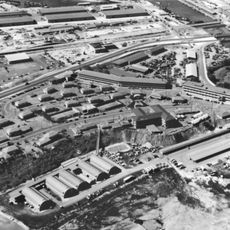
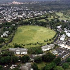
Admiral Clarey Bridge, Road bridge in Pearl Harbor, Hawaii

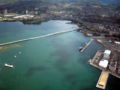
The Admiral Clarey Bridge connects Ford Island with Oahu through a combination of fixed and floating sections spanning approximately 1.4 kilometers. It serves as the main vehicle route within this naval base.

Completed in 1998, the bridge replaced two diesel-powered ferries that once served as the only transportation link to Ford Island for military personnel. This structure modernized access to the island.

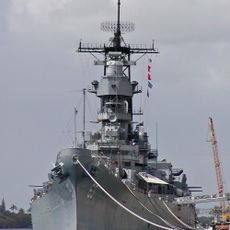
The bridge carries the name of Admiral Bernard Clarey, a submarine commander honored for his service during World War II. His name reflects the military heritage of this naval installation.

Access to the bridge requires a valid military identification card, as it is located within a secured naval base. Plan time for security checks when entering the facility.

The central section includes a floating moveable span of about 280 meters that retracts underneath the fixed portion to allow large naval vessels to pass through. This clever design lets the bridge serve both vehicle traffic and naval operations.

The community of curious travelers

AroundUs brings together thousands of curated places, local tips, and hidden gems, enriched daily by 60,000 contributors worldwide.

Start exploring
Inception
April 15, 1998
Official opening
April 15, 1998
Length
1,424 m
Made from material
concrete
GPS coordinates
21.36917,-157.94417
Latest update
December 8, 2025 19:51
Around this place
USS Missouri
United States of America

USS Missouri

1.2 km
Aloha Stadium
United States of America

Aloha Stadium

1.5 km
Naval Station Pearl Harbor
United States of America

Naval Station Pearl Harbor

2.2 km
Hickam Field
United States of America

Hickam Field

6.1 km
Koʻolau Range
United States of America

Koʻolau Range

10.1 km
Bishop Museum
United States of America

Bishop Museum

8.6 km
USS Bowfin
United States of America

USS Bowfin

495 m
Pacific Aviation Museum Pearl Harbor
United States of America

Pacific Aviation Museum Pearl Harbor

2.1 km
Fort Kamehameha
United States of America

Fort Kamehameha

5.3 km
Commander in Chief Pacific Fleet Headquarters
United States of America

Commander in Chief Pacific Fleet Headquarters

1.2 km
Hawaii Kotohira Jinsha – Hawaii Dazaifu Tenmangu
United States of America

Hawaii Kotohira Jinsha – Hawaii Dazaifu Tenmangu

9 km
Jhamandas Watumull Planetarium
United States of America

Jhamandas Watumull Planetarium

8.6 km
Submarine Memorial Chapel
United States of America

Submarine Memorial Chapel

1.6 km
Aloha Jewish Chapel
United States of America

Aloha Jewish Chapel

2 km
Keaīwa Heiau State Recreation Area
United States of America

Keaīwa Heiau State Recreation Area

5.9 km
Wakamiya Inari Shrine
United States of America

Wakamiya Inari Shrine

7.2 km
Kaumakapili Church
United States of America

Kaumakapili Church

9.6 km
Palm Circle
United States of America

Palm Circle

6 km
C. Brewer Building
United States of America

C. Brewer Building

10.2 km
Georges de S. Canavarro House
United States of America

Georges de S. Canavarro House

10.4 km
Hickam Harbor Beach
United States of America

Hickam Harbor Beach

5.8 km
Keʻehi Lagoon Beach
United States of America

Keʻehi Lagoon Beach

6.5 km
Waimalu Shopping Center
United States of America

Waimalu Shopping Center

1.9 km
Sharkey Theater
United States of America

Sharkey Theater

1.6 km
Iroquois Beach
United States of America

Iroquois Beach

7 km
Honolulu Magnetic Observatory
United States of America

Honolulu Magnetic Observatory

8.2 km
Fort Kamehameha Beach
United States of America

Fort Kamehameha Beach

6 km
Kai Beach
United States of America

Kai Beach

2.7 km
Show the full map
« Admiral Clarey Bridge - Road bridge in Pearl Harbor, Hawaii » is provided by Around Us (aroundus.com). Images and texts are derived from Wikimedia project under a Creative Commons license. You are allowed to copy, distribute, and modify copies of this page, under the conditions set by the license, as long as this note is clearly visible.

Discover hidden gems everywhere you go!

From secret cafés to breathtaking viewpoints, skip the crowded tourist spots and find places that match your style. Our app makes it easy with voice search, smart filtering, route optimization, and insider tips from travelers worldwide. Download now for the complete mobile experience.

Around Us App Screenshot

A unique approach to discovering new places

Le Figaro

All the places worth exploring

France Info

A tailor-made excursion in just a few clicks

20 Minutes

Around Us
Travel Guide & Maps
Download

Send to your phone

QR Code
1

Open the camera app on your mobile.

2

Point at the QR code with your camera. A notification will appear.

3

Tap the notification to open the link.