Chest opened
+${chestReward.xp} XP
Explorer
NOUVEAU ×${chestReward.collectible.quantity}
tapez pour fermer
Chest locked

Open chests in the app

Around Us is built for your phone — chests unlock when you walk, explore and capture nearby places.

Enable Location

We need your location to show you interesting places around you

Discover nearby places

Find interesting locations and hidden gems around you

Precise directions

Get accurate directions and distances to places

Your location is never shared with other users. It's only used when you tap the location button.

Marine Corps Air Station Kaneohe Bay

Log in to your account

Start exploring — it's free

Trusted by 73,084 travelers worldwide

Continue with Google
Continue with Apple
or

We will send you a code to connect

By continuing, you accept our Terms and Conditions and our Privacy Policy

Check your inbox

We've sent a pincode in your inbox. Please enter the code below.

Discussion Reviews 2 Photos
21k Popularity

Marine Corps Air Station Kaneohe Bay, US Marine Corps base in Hawaii, United States

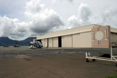
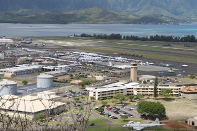
Marine Corps Air Station Kaneohe Bay is a military base on the Hawaiian island of Oahu, situated on the Mokapu Peninsula overlooking Kaneohe Bay. The facility has flat, open runways, historic hangars, administrative buildings, and regularly handles helicopter and fixed-wing aircraft operations.

The site began as an Army fort in 1918 for coastal defense, later expanding into a naval installation. The Navy commissioned the Naval Air Station Kaneohe in 1941, but it was attacked on December 7, 1941, before Pearl Harbor, resulting in the loss of numerous patrol aircraft and prompting the United States to enter World War II.

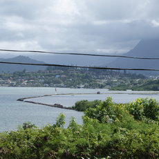
The station's name comes from Kaneohe Bay, which has deep meaning for the local community and serves as a reference point for the region. Today it functions as a gathering place where military ceremonies and community events honor those who have served and connect military personnel with residents.

Access to the active military base is restricted and requires proper authorization and identification checks. Early morning offers the best visibility for viewing aircraft movements and photography, as weather conditions tend to be clearer and flight operations typically increase at this time.

Hangar 1 still stands today, barely changed since the 1941 attack, serving as a silent witness to the destruction that occurred in the opening minutes of America's war. While many know about Pearl Harbor, few realize that bombing of this station actually began several minutes before that more famous attack.

The community of curious travelers

AroundUs brings together thousands of curated places, local tips, and hidden gems, enriched daily by 60,000 contributors worldwide.

Start exploring
Location
Architects
United States Navy
Elevation above the sea
7 m
GPS coordinates
21.44583,-157.76972
Latest update
February 7, 2026 22:18
Around this place
Plantation Estate
United States of America

Plantation Estate

3.7 km
United States of America

Kawai Nui Marsh

6.1 km
Boettcher Estate
United States of America

Boettcher Estate

5.6 km
He‘eia State Park
United States of America

He‘eia State Park

4.1 km
Kailua Beach
United States of America

Kailua Beach

5.2 km
Pyramid Rock
United States of America

Pyramid Rock

1.9 km
Kalama Beach
United States of America

Kalama Beach

5.5 km
United States of America

Pali Kilo

1.3 km
United States of America

Kuahine

3.9 km
Pyramid Rock Beach
United States of America

Pyramid Rock Beach

1.7 km
United States of America

North Beach

2.2 km
Fort Hase Beach
United States of America

Fort Hase Beach

3.5 km
United States of America

Kahekili Leap

4.8 km
Oneawa Beach
United States of America

Oneawa Beach

4.1 km
United States of America

Klipper Golf Course

2.3 km
United States of America

Bayview

4.4 km
United States of America

Castle Performing Arts Learning Center

5.1 km
United States of America

Scenic Lookout

3.1 km
United States of America

Scenic Lookout

3 km
United States of America

Pu’u Ma’eli’eli WWII bunker

5.5 km
United States of America

Monument featuring aircraft, aircraft model

1.8 km
United States of America

Monument featuring aircraft, aircraft model

1.6 km
United States of America

Aircraft model, monument featuring aircraft

1.6 km
United States of America

Monument featuring aircraft, aircraft model

1.7 km
United States of America

Monument featuring aircraft, aircraft model

1.6 km
United States of America

Aircraft model, monument featuring aircraft

1.7 km
United States of America

Monument featuring aircraft, aircraft model

1.6 km
United States of America

Monument featuring aircraft, aircraft model

1.8 km
Show the full map
Reviews
Share your experience

No review yet

Discussions
Start a discussion...

No discussion yet

« Marine Corps Air Station Kaneohe Bay - US Marine Corps base in Hawaii, United States » is provided by Around Us (aroundus.com). Images and texts are derived from Wikimedia project under a Creative Commons license. You are allowed to copy, distribute, and modify copies of this page, under the conditions set by the license, as long as this note is clearly visible.

Discover hidden gems everywhere you go!

From secret cafés to breathtaking viewpoints, skip the crowded tourist spots and find places that match your style. Our app makes it easy with voice search, smart filtering, route optimization, and insider tips from travelers worldwide. Download now for the complete mobile experience.

Around Us App Screenshot

A unique approach to discovering new places

Le Figaro

All the places worth exploring

France Info

A tailor-made excursion in just a few clicks

20 Minutes

Around Us
Travel Guide & Maps
Download

Send to your phone

QR Code
1

Open the camera app on your mobile.

2

Point at the QR code with your camera. A notification will appear.

3

Tap the notification to open the link.