Chest opened
+${chestReward.xp} XP
Explorer
NOUVEAU ×${chestReward.collectible.quantity}
tapez pour fermer
Chest locked

Open chests in the app

Around Us is built for your phone — chests unlock when you walk, explore and capture nearby places.

Enable Location

We need your location to show you interesting places around you

Discover nearby places

Find interesting locations and hidden gems around you

Precise directions

Get accurate directions and distances to places

Your location is never shared with other users. It's only used when you tap the location button.

Log in to your account

Start exploring — it's free

Trusted by 72,935 travelers worldwide

Continue with Google
Continue with Apple
or

We will send you a code to connect

By continuing, you accept our Terms and Conditions and our Privacy Policy

Check your inbox

We've sent a pincode in your inbox. Please enter the code below.

Xalisco, Nayarit
Discussion Reviews Photo
13.7k Popularity

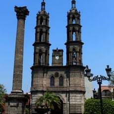
Xalisco, Nayarit, Municipality center in Nayarit, Mexico.

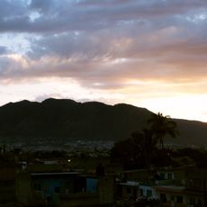
Xalisco is a municipality center located in the mountainous state of Nayarit at roughly 1,349 meters (4,428 feet) elevation. The surrounding terrain features steep slopes and the prominent Cerro Alto peak at 2,240 meters (7,349 feet), creating a landscape of ridges and valleys.

The name comes from Nahuatl origins, combining xal-li meaning sand, ix-telotl meaning eye, and ko meaning place to form the phrase Place of the Sandy Eye. This indigenous naming reflects the region's pre-Hispanic roots and the natural features that have long defined the area.

The annual Assumption of the Virgin Mary festival on August 15 draws the community together to honor the patron saint while marking the start of the corn harvest season. During this time, the town fills with religious processions and celebrations centered on corn, reflecting deep agricultural and spiritual roots.

The location sits roughly 6 to 7 kilometers southwest of Tepic and is easily accessible by car, with connections to nearby municipalities like Compostela, Santiago Ixcuintla, and San Blas. The hilly terrain means walking between areas can be tiring, so planning routes with proper footwear or local transport helps.

The region produces an unusually diverse range of crops including rice, corn, avocados, lemons, oranges, bananas, coffee, cherries, and sugarcane on the same farmland. This mix of tropical and subtropical agriculture is rare for a single area and shapes much of the local economy and rural character.

The community of curious travelers

AroundUs brings together thousands of curated places, local tips, and hidden gems, enriched daily by 60,000 contributors worldwide.

Start exploring
Location
Elevation above the sea
1,349 m
GPS coordinates
21.44417,-104.90167
Latest update
December 7, 2025 20:25
Reviews
Share your experience

No review yet

Discussions
Start a discussion...

No discussion yet

« Xalisco, Nayarit - Municipality center in Nayarit, Mexico » is provided by Around Us (aroundus.com). Images and texts are derived from Wikimedia project under a Creative Commons license. You are allowed to copy, distribute, and modify copies of this page, under the conditions set by the license, as long as this note is clearly visible.

Discover hidden gems everywhere you go!

From secret cafés to breathtaking viewpoints, skip the crowded tourist spots and find places that match your style. Our app makes it easy with voice search, smart filtering, route optimization, and insider tips from travelers worldwide. Download now for the complete mobile experience.

Around Us App Screenshot

A unique approach to discovering new places

Le Figaro

All the places worth exploring

France Info

A tailor-made excursion in just a few clicks

20 Minutes

Around Us
Travel Guide & Maps
Download

Send to your phone

QR Code
1

Open the camera app on your mobile.

2

Point at the QR code with your camera. A notification will appear.

3

Tap the notification to open the link.