Walnut, Suburban city in Los Angeles County, United States
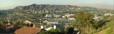
Walnut is a suburban community in Los Angeles County, California, positioned between the San Jose Hills to the north and the Puente Hills to the south. The city rests at an elevation of roughly 171 meters and offers residential neighborhoods with views of both hill ranges.
Before its incorporation as a city in 1959, the area belonged to Californio rancher Ricardo Vejar, who owned both Rancho Los Nogales and Rancho San José. These Mexican land grants shaped the region's early history during the 19th century.
The annual Mt. SAC Relays track and field festival at Hilmer Lodge Stadium draws athletes from around the world and brings competitive sports into the community. The event takes place on the Mount San Antonio College campus and connects local spectators with international sporting moments.
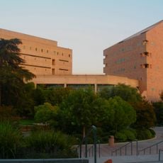
The community lies roughly 30 miles east of downtown Los Angeles and is accessible via several highways. The Walnut Valley Unified School District operates elementary, middle and high schools with strong academic standards for families in the area.
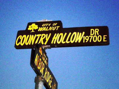
The city takes its name from Rancho Los Nogales, a Mexican land grant, with nogales meaning walnut trees in Spanish. This linguistic connection links the modern community directly to the agricultural past of the region.
Location: Los Angeles County
Inception: 1959
Elevation above the sea: 171 m
Shares border with: West Covina, Covina, San Dimas, Pomona, Diamond Bar, Rowland Heights, City of Industry, La Puente
Website: http://cityofwalnut.org
GPS coordinates: 34.03333,-117.86667
Latest update: December 13, 2025 19:29
CLA Building
5.2 km
Puddingstone Reservoir
8.3 km
Phillips Mansion
7 km
Frank G. Bonelli Regional Park
8.2 kmCovina Center for the Performing Arts
6.3 kmBronco Student Center
4.9 km
Campus de Cal Poly Pomona y reserva ecológica Voorhis
4.9 kmSummit Ridge Park
7.6 kmKelby Park
7 kmArnold Reservoir
8.7 kmVia Verde Country Club
6.1 kmNeptune's Fury
8.5 kmThe Industry Hills Golf Club - Ike (Dwight D Eisenhower) Course
5.9 kmThe Industry Hills Golf Club - Babe Zaharias Course
5.7 kmRowland Heights Golf Center
5.4 kmSouth Hills Country Club
3.1 kmThe Industry Hills Golf Club (Dwight D Eisenhower & Babe Zaharias)
5.8 kmCPP
4.7 kmBonita Center for the Arts
8.2 kmDiamond Bar Golf Course
4.9 kmJaguar
7.6 kmChapparel Middle School Sign
6.1 kmStatue, Work of art
5 kmWork of art
4.5 kmWork of art
4.9 kmWork of art
5.3 kmStatue, Work of art
4.5 kmMural, Work of art
6.3 kmVisited this place? Tap the stars to rate it and share your experience / photos with the community! Try now! You can cancel it anytime.
Discover hidden gems everywhere you go!
From secret cafés to breathtaking viewpoints, skip the crowded tourist spots and find places that match your style. Our app makes it easy with voice search, smart filtering, route optimization, and insider tips from travelers worldwide. Download now for the complete mobile experience.
A unique approach to discovering new places❞
— Le Figaro
All the places worth exploring❞
— France Info
A tailor-made excursion in just a few clicks❞
— 20 Minutes