Enable Location

We need your location to show you interesting places around you

Discover nearby places

Find interesting locations and hidden gems around you

Precise directions

Get accurate directions and distances to places

Your location is never shared with other users. It's only used when you tap the location button.

Distrito Central

Log in to your account

Start exploring — it's free

Trusted by 62,617 travelers worldwide

Continue with Google
Continue with Apple
or

We will send you a code to connect

By continuing, you accept our Terms and Conditions and our Privacy Policy

Check your inbox

We've sent a pincode in your inbox. Please enter the code below.

Distrito Central, Administrative division in Tegucigalpa, Honduras

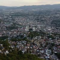
Distrito Central is an administrative area that unites Tegucigalpa and Comayagüela into one region. It houses the seat of government, major public institutions, and numerous residential neighborhoods where daily life unfolds across varying terrain.

The region was formed in 1937 when two separate cities merged into one administrative entity. This consolidation created the foundation for the modern capital and centralized government functions in a single location.

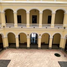
Government buildings and the university form the heart of the region, where political and academic life centers itself. You can observe how these institutions shape daily routines and draw people from across the country.

The area is spread out across varied terrain with many distinct neighborhoods, so it helps to plan movements by specific sections when exploring. Access is mainly by road, as the region operates without a railroad system.

The region has an international airport that serves as the main entry point for travelers and goods. This makes it a central hub for movement and commerce despite the absence of rail transport.

The community of curious travelers

AroundUs brings together thousands of curated places, local tips, and hidden gems, enriched daily by 60,000 contributors worldwide.

Start exploring
Inception
January 30, 1937
Capital city
Tegucigalpa
Elevation above the sea
980 m
Website
GPS coordinates
14.10574,-87.20401
Latest update
December 17, 2025 10:09
Administrative divisions
« Distrito Central - Administrative division in Tegucigalpa, Honduras » is provided by Around Us (aroundus.com). Images and texts are derived from Wikimedia project under a Creative Commons license. You are allowed to copy, distribute, and modify copies of this page, under the conditions set by the license, as long as this note is clearly visible.

Discover hidden gems everywhere you go!

From secret cafés to breathtaking viewpoints, skip the crowded tourist spots and find places that match your style. Our app makes it easy with voice search, smart filtering, route optimization, and insider tips from travelers worldwide. Download now for the complete mobile experience.

Around Us App Screenshot

A unique approach to discovering new places

Le Figaro

All the places worth exploring

France Info

A tailor-made excursion in just a few clicks

20 Minutes

Around Us
Travel Guide & Maps
Download

Send to your phone

QR Code
1

Open the camera app on your mobile.

2

Point at the QR code with your camera. A notification will appear.

3

Tap the notification to open the link.