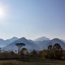
La Tigra National Park, Mountainous national park in Francisco Morazán Department, Honduras.
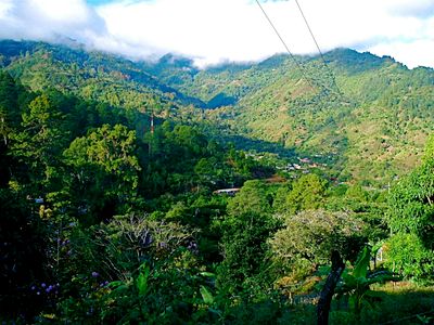
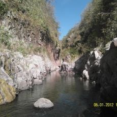
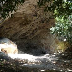
La Tigra is a cloud forest area in Francisco Morazán that spreads across wooded mountain slopes and deep valleys. Visitors find two separate entrance areas that open different routes through the dense greenery.
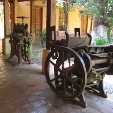
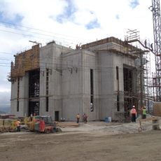
The area served mining operations for many years before being placed under protection in the mid-20th century. Three decades later it officially received park status to preserve the remaining forests.
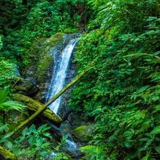
The name La Tigra recalls the jaguars that once roamed these mountain forests, while today hikers follow the quiet trails under shifting mist. Local groups regularly use the well-trodden paths for day trips and birdwatching beneath the canopy.
Hikers can choose between short walks and longer routes that take several hours through forest and over ridges. Mist often drifts across the trails, so an extra layer of clothing helps against the dampness and chill.
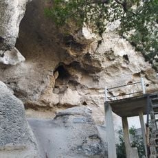
Old mining structures still stand among the trees, recalling the earlier industrial use of the slopes. Water from these high slopes flows directly into the pipes of the nearby capital.
Location: Francisco Morazán Department
Inception: 1980
GPS coordinates: 14.20667,-87.09972
Latest update: December 5, 2025 22:28
Honduras holds a range of natural sites and archaeological locations along its Caribbean coastline and mountainous interior. The Copán ruins stand among the most important remnants of the Mayan civilization, displaying intricate stonework and the Hieroglyphic Stairway. Several islands in the Bay Islands, including Roatán, Utila, and Guanaja, offer sandy shores and access to coral reefs. National parks such as Pico Bonito, La Tigra, and Celaque protect rainforests and mountain ecosystems with trails through dense vegetation. Lake Yojoa sits between forested hills and serves as a habitat for migratory birds. The capital city of Tegucigalpa contains the 18th-century cathedral, along with the Museum for National Identity and the Garífuna Cultural Center, which provide insight into the country's history and culture. The Christ of Picacho statue overlooks the city from a hilltop. Along the northern coast, the Lancetilla Botanical Garden in Tela holds collections of tropical plants. Protected areas like the Río Plátano Biosphere Reserve and the Moskitia region in the east preserve remote rainforests and wetlands. Cayos Cochinos consists of small islands with clear waters off the coast near La Ceiba.
Choluteca Bridge
100.1 km
Virgin of Suyapa
15.4 km
Christ at El Picacho
14.4 km
Immaculate Conception Cathedral, Comayagua
64.8 km
Manuel Bonilla National Theater
16.3 km
Basílica de Suyapa
15.4 km
Cerro Azul Meámbar National Park
110.8 km
Somoto Canyon National Monument
94 km
Montaña de Comayagua National Park
54.8 km
Juan Ramón Molina National Library
15.9 km
Museum of Comayagua
65 km
Museo del Hombre Hondureño
15.8 km
Chiminike
18.8 km
Holy Spirit Grotto
102.8 km
Tegucigalpa Honduras Temple
22.7 km
Estadio Emilio Williams Agasse
101.6 km
Colegio Tridentino de Comayagua
65 km
Monumento a la Constitución de 1812
64.6 km
Museo Colonial de Arte Religioso
64.8 km
Museum for National Identity
16.2 km
Museo Histórico y Cívico Casa Cabañas
64.9 km
Playa Blanca
113.3 km
Playa de Ratón
109.8 km
Museo Numismatico
18.9 km
Iglesia Ciudad Antigua
106.4 km
Cueva El Gigante
103.4 km
Playa del Muerto
112 km
Playa Secundino
112.9 kmVisited this place? Tap the stars to rate it and share your experience / photos with the community! Try now! You can cancel it anytime.
Discover hidden gems everywhere you go!
From secret cafés to breathtaking viewpoints, skip the crowded tourist spots and find places that match your style. Our app makes it easy with voice search, smart filtering, route optimization, and insider tips from travelers worldwide. Download now for the complete mobile experience.
A unique approach to discovering new places❞
— Le Figaro
All the places worth exploring❞
— France Info
A tailor-made excursion in just a few clicks❞
— 20 Minutes