Enable Location

We need your location to show you interesting places around you

Discover nearby places

Find interesting locations and hidden gems around you

Precise directions

Get accurate directions and distances to places

Your location is never shared with other users. It's only used when you tap the location button.

Brownsville & Matamoros International Bridge

Log in to your account

Join the adventure

Create your free account and start exploring (like 60k+ others)

We will send you a code to connect

or
Continue with Google
Continue with Apple
By continuing, you accept our Terms and Conditions and our Privacy Policy

Check your inbox

We've sent a pincode in your inbox. Please enter the code below.

Brownsville & Matamoros International Bridge

Brownsville & Matamoros International Bridge, International border crossing between Brownsville, Texas and Matamoros, Mexico.

Description

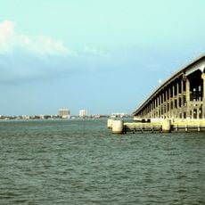
The Brownsville & Matamoros International Bridge connects Texas with Mexico across the Rio Grande and accommodates multiple lanes for vehicles and railway traffic. The facility consists of two parallel structures handling different types of transportation with significant overall capacity.

History

The original structure opened in 1910 as the first railway connection between the two regions. A second structure for road traffic was added later to meet growing transportation demands.

Culture

The bridge enables daily interactions between communities on both sides through commerce and family visits. People use it regularly to maintain their lives across both nations.

Practical

The bridge experiences heaviest traffic during daytime and early evening hours, with morning and afternoon rush times causing longer waits. Regular border crossers can use systems that speed up the passage process.

Did you know?

The bridge system comprises two historically different structures, with the older one serving rail traffic while the newer one consists of four lanes for cars. These side-by-side structures reveal the evolution of infrastructure across more than a century.

Location
Location
Part of
Mexico–United States border
GPS coordinates
25.89194,-97.50444
Latest update
December 8, 2025 19:55

AroundUs brings together thousands of curated places, local tips, and hidden gems, enriched daily by 60,000 contributors worldwide. Discover all places nearby (Texas).

« Brownsville & Matamoros International Bridge - International border crossing between Brownsville, Texas and Matamoros, Mexico » is provided by Around Us (aroundus.com). Images and texts are derived from Wikimedia project under a Creative Commons license. You are allowed to copy, distribute, and modify copies of this page, under the conditions set by the license, as long as this note is clearly visible.

Discover hidden gems everywhere you go!

From secret cafés to breathtaking viewpoints, skip the crowded tourist spots and find places that match your style. Our app makes it easy with voice search, smart filtering, route optimization, and insider tips from travelers worldwide. Download now for the complete mobile experience.

Around Us App Screenshot

A unique approach to discovering new places

Le Figaro

All the places worth exploring

France Info

A tailor-made excursion in just a few clicks

20 Minutes

Around Us
Travel Guide & Maps
Download

Send to your phone

QR Code
1

Open the camera app on your mobile.

2

Point at the QR code with your camera. A notification will appear.

3

Tap the notification to open the link.