Palmito Ranch Battlefield

Log in to your account

AroundUs is a community-driven map of interesting places, built by curious explorers like you. It grows with every review, story, and photo you share.
Connect to save your favorite spots, contribute locations, and create personalized routes.
Continue with Google
Continue with Apple
Continue with X
Continue with Facebook
Continue with email
By continuing, you accept our Terms and Conditions and our Privacy Policy
Create an account
Add to collection
Map
Suggest a change
Share

Palmito Ranch Battlefield, Historic site in Cameron County, United States.
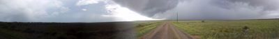
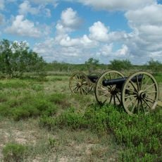
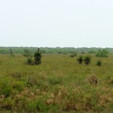
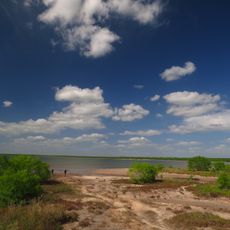
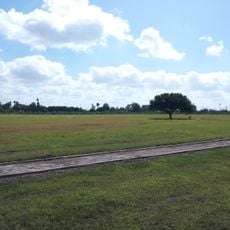
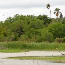
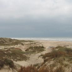
Palmito Ranch Battlefield sits along the Rio Grande riverbanks in a landscape of grasslands and shallow marshes that have remained largely unchanged since the Civil War era. The terrain is flat and open, making it easy to understand how troops moved and positioned themselves during the fighting.

The last land battle of the Civil War took place here on May 12-13, 1865, weeks after the Confederate surrender at Appomattox. Despite that surrender, Confederate forces pushed back Union troops in a final victory that happened long after most fighting had ended.

This site honors soldiers from both armies who fought in the final military clash of the Civil War. Visitors can learn about their stories through markers and displays that acknowledge the sacrifice of those who participated in this forgotten engagement.

Visitors can reach the site at the intersection of Palmito Hill Road and Boca Chica Highway east of Brownsville. The ground is flat and accessible, though there is little shade, so bring water and sun protection when exploring the area.

This battlefield saw a rare occurrence: a Confederate victory weeks after the war officially ended and most soldiers had already laid down their weapons. It stands as an unexpected final chapter at a moment when fighting had ceased almost everywhere else.

Location: Texas

Location: Cameron County

Address: Between TX 4 (Boca Chica Hwy.) and the Rio Grande, approximately 12 mi. E of Brownsville

GPS coordinates: 25.94667,-97.28528

Latest update: December 12, 2025 07:56

Photos
Around this place
Queen Isabella Causeway
United States of America

Queen Isabella Causeway

18.3 km
Fort Brown
United States of America

Fort Brown

22 km
Gladys Porter Zoo
United States of America

Gladys Porter Zoo

21.5 km
Palo Alto Battlefield National Historical Park
United States of America

Palo Alto Battlefield National Historical Park

20.1 km
Estadio El Hogar
Mexico

Estadio El Hogar

25.2 km
Laguna Atascosa National Wildlife Refuge
United States of America

Laguna Atascosa National Wildlife Refuge

38.8 km
Lower Rio Grande Valley National Wildlife Refuge
United States of America

Lower Rio Grande Valley National Wildlife Refuge

62.7 km
STARGATE
United States of America

STARGATE

10.7 km
Pier 19
United States of America

Pier 19

18.6 km
Isla Blanca Park
United States of America

Isla Blanca Park

18.7 km
Point Isabel Lighthouse
United States of America

Point Isabel Lighthouse

16.5 km
Sabal Palm Sanctuary
United States of America

Sabal Palm Sanctuary

16.9 km
Parque Olímpico
Mexico

Parque Olímpico

22.7 km
Our Lady of Refuge Cathedral, Matamoros
Mexico

Our Lady of Refuge Cathedral, Matamoros

23.1 km
Fuerte Castamata
Mexico

Fuerte Castamata

22.6 km
Immaculate Conception Cathedral
United States of America

Immaculate Conception Cathedral

21.7 km
Resaca de la Palma Battlefield
United States of America

Resaca de la Palma Battlefield

20.1 km
Estero Llano Grande State Park
United States of America

Estero Llano Grande State Park

70.1 km
Old Brulay Plantation
United States of America

Old Brulay Plantation

15.4 km
Cameron County Courthouse
United States of America

Cameron County Courthouse

21.6 km
United States Court House, Custom House, and Post Office
United States of America

United States Court House, Custom House, and Post Office

22 km
Museo del Ferrocarril de Matamoros
Mexico

Museo del Ferrocarril de Matamoros

23.4 km
Isla Blanca Beach
United States of America

Isla Blanca Beach

19 km
Iwo Jima Museum Gift Shop
United States of America

Iwo Jima Museum Gift Shop

49.1 km
Brownsville Heritage Museum
United States of America

Brownsville Heritage Museum

21.7 km
Outdoor theater
Mexico

Outdoor theater

61.8 km
Boca Chica State Park
United States of America

Boca Chica State Park

14.5 km
Del Mar Beach
United States of America

Del Mar Beach

16.1 km
Show the full map
Reviews

Visited this place? Tap the stars to rate it and share your experience / photos with the community! Try now! You can cancel it anytime.

« Palmito Ranch Battlefield - Historic site in Cameron County, United States » is provided by Around Us (aroundus.com). Images and texts are derived from Wikimedia project under a Creative Commons license. You are allowed to copy, distribute, and modify copies of this page, under the conditions set by the license, as long as this note is clearly visible.

Discover hidden gems everywhere you go!

From secret cafés to breathtaking viewpoints, skip the crowded tourist spots and find places that match your style. Our app makes it easy with voice search, smart filtering, route optimization, and insider tips from travelers worldwide. Download now for the complete mobile experience.

Around Us App Screenshot

A unique approach to discovering new places

Le Figaro

All the places worth exploring

France Info

A tailor-made excursion in just a few clicks

20 Minutes