Chest opened
+${chestReward.xp} XP
Explorer
NOUVEAU ×${chestReward.collectible.quantity}
tapez pour fermer
Chest locked

Open chests in the app

Around Us is built for your phone — chests unlock when you walk, explore and capture nearby places.

Enable Location

We need your location to show you interesting places around you

Discover nearby places

Find interesting locations and hidden gems around you

Precise directions

Get accurate directions and distances to places

Your location is never shared with other users. It's only used when you tap the location button.

Log in to your account

Start exploring — it's free

Trusted by 72,874 travelers worldwide

Continue with Google
Continue with Apple
or

We will send you a code to connect

By continuing, you accept our Terms and Conditions and our Privacy Policy

Check your inbox

We've sent a pincode in your inbox. Please enter the code below.

Llano Uplift
Discussion Reviews Photo
18.7k Popularity

Llano Uplift, Mountain range in Central Texas, US

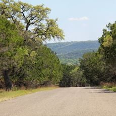
The Llano Uplift is a mountain range in Central Texas spanning about 90 miles and displays Precambrian-era rock formations. The landscape is shaped by the Llano River and extends across five different counties with varying terrain types.

The rock formations developed over 1.3 billion years ago and were exposed through erosion over extended periods. These geological processes shaped the current landscape and make the area a window into Earth's deep past.

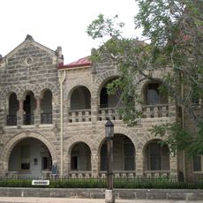
The area has long been known for its granite quarries, which supply pink granite used in construction projects throughout the state. Visitors can see the marks of this mining activity in the landscape, shaping the economic life of nearby communities.

The area is made accessible through several state parks that offer hiking trails and outdoor activities. Visitors should note that the region is in Central Texas and remains warm year-round.

The area holds the only known deposits of the mineral llanite and contains rare earth elements within its rock formations. These geological features make this location of considerable scientific interest to mineral collectors and geologists.

The community of curious travelers

AroundUs brings together thousands of curated places, local tips, and hidden gems, enriched daily by 60,000 contributors worldwide.

Start exploring
Location
GPS coordinates
30.17420,-99.06530
Latest update
December 7, 2025 10:08
Around this place
Kerrville-Schreiner Park
United States of America

Kerrville-Schreiner Park

19 km
Capt. Charles Schreiner Mansion
United States of America

Capt. Charles Schreiner Mansion

16 km
United States of America

Museum of Western Art

18 km
The Coming King Sculpture Prayer Gardens
United States of America

The Coming King Sculpture Prayer Gardens

12.4 km
United States of America

Riverside Nature Center

15.8 km
Masonic Building
United States of America

Masonic Building

16 km
Morris Ranch Schoolhouse
United States of America

Morris Ranch Schoolhouse

6.9 km
Wrede School
United States of America

Wrede School

16.4 km
United States of America

Ravenhead

18.3 km
United States of America

Kerrville City Park

16.3 km
United States of America

A. C. Schreiner, Jr. Home

15.7 km
United States of America

Millwood Observatory

19.5 km
United States of America

The Cypress Creek School

19.5 km
United States of America

Kerrville Lake

19.3 km
United States of America

Liveoak Creek Log Cabin

18.2 km
United States of America

Lehne-Itz House

19 km
United States of America

Tulahteka

17.1 km
United States of America

First Presbyterian Church of Kerrville

15.6 km
United States of America

Captain Charles Schreiner

14 km
United States of America

The Comparette Home

15.7 km
United States of America

Captain Charles Schreiner Home

14 km
Guthrie Building
United States of America

Guthrie Building

15.9 km
United States of America

Scott Schreiner Golf Course

14.2 km
United States of America

Lady Bird Johnson Municipal Golf Course

16.2 km
United States of America

The Cross at Kerrville

12.1 km

Old Arcadia Theater

16.1 km
United States of America

Lupe

16.3 km
United States of America

Scenic viewpoint

16.4 km
Show the full map
Reviews
Share your experience

No review yet

Discussions
Start a discussion...

No discussion yet

« Llano Uplift - Mountain range in Central Texas, US » is provided by Around Us (aroundus.com). Images and texts are derived from Wikimedia project under a Creative Commons license. You are allowed to copy, distribute, and modify copies of this page, under the conditions set by the license, as long as this note is clearly visible.

Discover hidden gems everywhere you go!

From secret cafés to breathtaking viewpoints, skip the crowded tourist spots and find places that match your style. Our app makes it easy with voice search, smart filtering, route optimization, and insider tips from travelers worldwide. Download now for the complete mobile experience.

Around Us App Screenshot

A unique approach to discovering new places

Le Figaro

All the places worth exploring

France Info

A tailor-made excursion in just a few clicks

20 Minutes

Around Us
Travel Guide & Maps
Download

Send to your phone

QR Code
1

Open the camera app on your mobile.

2

Point at the QR code with your camera. A notification will appear.

3

Tap the notification to open the link.