Enable Location

We need your location to show you interesting places around you

Discover nearby places

Find interesting locations and hidden gems around you

Precise directions

Get accurate directions and distances to places

Your location is never shared with other users. It's only used when you tap the location button.

Paddock Viaduct

Log in to your account

Start exploring — it's free

Trusted by 61,983 travelers worldwide

Continue with Google
Continue with Apple
or

We will send you a code to connect

By continuing, you accept our Terms and Conditions and our Privacy Policy

Check your inbox

We've sent a pincode in your inbox. Please enter the code below.

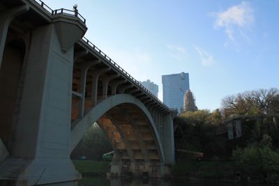
Paddock Viaduct, Road bridge in Fort Worth, United States

Paddock Viaduct is a road bridge spanning the Trinity River in Fort Worth, connecting downtown to the northern areas of the city using reinforced concrete arch construction. The structure serves as a major transportation corridor and displays the engineering approach typical of its era.

The viaduct was constructed in 1914 by the engineering firm Brenneke and Fay to replace an inadequate suspension bridge from the 1890s. This new structure represented a major advancement in connecting the city's different areas.

The bridge carries the name of B. B. Paddock, a key political figure in Fort Worth's early development whose influence shaped the city's infrastructure. Local residents view this crossing as a physical link to the city's formative period.

The bridge remains open year-round for both vehicle and pedestrian traffic crossing the river. Regular maintenance work has been performed over the decades to keep the structure safe and usable.

The bridge was groundbreaking for employing self-supporting reinforcing steel within its concrete arches, making it an early example of this construction technique in the country. This technical innovation distinguished it during an important period of bridge engineering development.

The community of curious travelers

AroundUs brings together thousands of curated places, local tips, and hidden gems, enriched daily by 60,000 contributors worldwide.

Start exploring
Location
Address
Main St.
GPS coordinates
32.75928,-97.33441
Latest update
December 14, 2025 11:02
Around this place
Bass Performance Hall
United States of America

Bass Performance Hall

639 m
Tarrant County Courthouse
United States of America

Tarrant County Courthouse

275 m
Sid Richardson Museum
United States of America

Sid Richardson Museum

495 m
Sinclair Building
United States of America

Sinclair Building

670 m
Fort Worth Library
United States of America

Fort Worth Library

578 m
Knights of Pythias Building
United States of America

Knights of Pythias Building

542 m
Bank of America Tower
United States of America

Bank of America Tower

502 m
F. W. Woolworth Building
United States of America

F. W. Woolworth Building

644 m
Butler Place Historic District
United States of America

Butler Place Historic District

676 m
Wells Fargo Tower
United States of America

Wells Fargo Tower

403 m
Heritage Park Plaza
United States of America

Heritage Park Plaza

120 m
City Center Towers Complex
United States of America

City Center Towers Complex

485 m
Burk Burnett Building
United States of America

Burk Burnett Building

674 m
Stephen F. Austin Elementary School
United States of America

Stephen F. Austin Elementary School

674 m
William J. Bryce House
United States of America

William J. Bryce House

676 m
Elizabeth Boulevard Historic District
United States of America

Elizabeth Boulevard Historic District

674 m
Bryce Building
United States of America

Bryce Building

674 m
First National Bank Building
United States of America

First National Bank Building

669 m
Cotton Belt Railroad Industrial Historic District
United States of America

Cotton Belt Railroad Industrial Historic District

676 m
Thomas Shiels House
United States of America

Thomas Shiels House

674 m
Inspiration Point Shelter House
United States of America

Inspiration Point Shelter House

676 m
First National Bank Building
United States of America

First National Bank Building

648 m
Mineola Downtown Historic District
United States of America

Mineola Downtown Historic District

676 m
Eighth Avenue Historic District
United States of America

Eighth Avenue Historic District

674 m
Central Handley Historic District
United States of America

Central Handley Historic District

674 m
Grand Avenue Historic District
United States of America

Grand Avenue Historic District

674 m
Leuda-May Historic District
United States of America

Leuda-May Historic District

674 m
AMC Sundance 11
United States of America

AMC Sundance 11

487 m
Show the full map
« Paddock Viaduct - Road bridge in Fort Worth, United States » is provided by Around Us (aroundus.com). Images and texts are derived from Wikimedia project under a Creative Commons license. You are allowed to copy, distribute, and modify copies of this page, under the conditions set by the license, as long as this note is clearly visible.

Discover hidden gems everywhere you go!

From secret cafés to breathtaking viewpoints, skip the crowded tourist spots and find places that match your style. Our app makes it easy with voice search, smart filtering, route optimization, and insider tips from travelers worldwide. Download now for the complete mobile experience.

Around Us App Screenshot

A unique approach to discovering new places

Le Figaro

All the places worth exploring

France Info

A tailor-made excursion in just a few clicks

20 Minutes

Around Us
Travel Guide & Maps
Download

Send to your phone

QR Code
1

Open the camera app on your mobile.

2

Point at the QR code with your camera. A notification will appear.

3

Tap the notification to open the link.