Enable Location

We need your location to show you interesting places around you

Discover nearby places

Find interesting locations and hidden gems around you

Precise directions

Get accurate directions and distances to places

Your location is never shared with other users. It's only used when you tap the location button.

Butler Place Historic District

Log in to your account

Start exploring — it's free

Trusted by 61,469 travelers worldwide

Continue with Google
Continue with Apple
or

We will send you a code to connect

By continuing, you accept our Terms and Conditions and our Privacy Policy

Check your inbox

We've sent a pincode in your inbox. Please enter the code below.

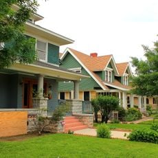
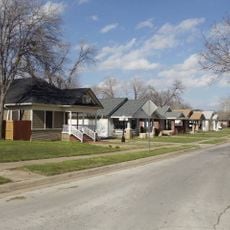
Butler Place Historic District, Public housing complex in Fort Worth, United States.

Description

Butler Place Historic District is a residential development in Fort Worth featuring Colonial Revival brick buildings laid out across land between downtown and major highways. The structures create a cohesive neighborhood with consistent architectural character throughout the area.

History

The district was established in 1941 by the Fort Worth Housing Authority as one of 52 federal housing projects created during the Great Depression. Its founding represented a significant moment in the city's approach to affordable housing.

Culture

The district takes its name from Henry Harrison Butler, a Civil War veteran who became Fort Worth's first African American teacher. His legacy remains central to the identity of this residential community.

Practical

The district is located near Interstate 30, Interstate 35W, and US Highway 287, making it easy to reach by car. The I.M. Terrell Academy on its southern edge serves as a helpful orientation point.

Did you know?

When it opened, rental prices ranged from 15.50 to 16.75 dollars monthly, with residents required to earn less than six times the rent amount. These low rates were central to the project's goal of providing housing for working families.

Location
Architectural style
Colonial Revival architecture
Address
Roughly bounded by Luella St., I.M. Terrell Way Cir. M., 19th St. & I 35W
GPS coordinates
32.75890,-97.32720
Latest update
December 14, 2025 11:42

AroundUs brings together thousands of curated places, local tips, and hidden gems, enriched daily by 60,000 contributors worldwide. Discover all places nearby (Fort Worth).

Around this place
Blackstone Hotel
United States of America

Blackstone Hotel

644 m
Tarrant County Courthouse
United States of America

Tarrant County Courthouse

555 m
Sid Richardson Museum
United States of America

Sid Richardson Museum

557 m
Sinclair Building
United States of America

Sinclair Building

650 m
Knights of Pythias Building
United States of America

Knights of Pythias Building

545 m
Bank of America Tower
United States of America

Bank of America Tower

445 m
Paddock Viaduct
United States of America

Paddock Viaduct

676 m
Wells Fargo Tower
United States of America

Wells Fargo Tower

513 m
Heritage Park Plaza
United States of America

Heritage Park Plaza

669 m
City Center Towers Complex
United States of America

City Center Towers Complex

480 m
Burk Burnett Building
United States of America

Burk Burnett Building

2 m
Stephen F. Austin Elementary School
United States of America

Stephen F. Austin Elementary School

2 m
William J. Bryce House
United States of America

William J. Bryce House

0 m
Elizabeth Boulevard Historic District
United States of America

Elizabeth Boulevard Historic District

2 m
Morning Chapel Colored Methodist Episcopal Church
United States of America

Morning Chapel Colored Methodist Episcopal Church

164 m
Bryce Building
United States of America

Bryce Building

2 m
Saint James Second Street Baptist Church
United States of America

Saint James Second Street Baptist Church

265 m
Cotton Belt Railroad Industrial Historic District
United States of America

Cotton Belt Railroad Industrial Historic District

0 m
Thomas Shiels House
United States of America

Thomas Shiels House

2 m
Inspiration Point Shelter House
United States of America

Inspiration Point Shelter House

0 m
First National Bank Building
United States of America

First National Bank Building

587 m
Mineola Downtown Historic District
United States of America

Mineola Downtown Historic District

0 m
Eighth Avenue Historic District
United States of America

Eighth Avenue Historic District

2 m
Central Handley Historic District
United States of America

Central Handley Historic District

2 m
Grand Avenue Historic District
United States of America

Grand Avenue Historic District

2 m
Leuda-May Historic District
United States of America

Leuda-May Historic District

2 m
AMC Sundance 11
United States of America

AMC Sundance 11

668 m
Angels sculptures
United States of America

Angels sculptures

499 m
Show the full map
« Butler Place Historic District - Public housing complex in Fort Worth, United States » is provided by Around Us (aroundus.com). Images and texts are derived from Wikimedia project under a Creative Commons license. You are allowed to copy, distribute, and modify copies of this page, under the conditions set by the license, as long as this note is clearly visible.

Discover hidden gems everywhere you go!

From secret cafés to breathtaking viewpoints, skip the crowded tourist spots and find places that match your style. Our app makes it easy with voice search, smart filtering, route optimization, and insider tips from travelers worldwide. Download now for the complete mobile experience.

Around Us App Screenshot

A unique approach to discovering new places

Le Figaro

All the places worth exploring

France Info

A tailor-made excursion in just a few clicks

20 Minutes

Around Us
Travel Guide & Maps
Download

Send to your phone

QR Code
1

Open the camera app on your mobile.

2

Point at the QR code with your camera. A notification will appear.

3

Tap the notification to open the link.