Enable Location

We need your location to show you interesting places around you

Discover nearby places

Find interesting locations and hidden gems around you

Precise directions

Get accurate directions and distances to places

Your location is never shared with other users. It's only used when you tap the location button.

Carruthers Field

Log in to your account

Start exploring — it's free

Trusted by 61,984 travelers worldwide

Continue with Google
Continue with Apple
or

We will send you a code to connect

By continuing, you accept our Terms and Conditions and our Privacy Policy

Check your inbox

We've sent a pincode in your inbox. Please enter the code below.

Carruthers Field

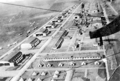
Carruthers Field, Former military airfield in Benbrook, Texas

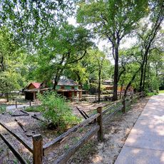
Carruthers Field was a former military airfield located about half a mile north of Benbrook with 16 hangars arranged around a central flying area for training operations. Today the site has been developed into residential neighborhoods, though concrete remnants from the original structures remain scattered across the area.

Established in 1917 as Taliaferro Field #3, the airfield served to train American and Canadian pilots during World War I under a Royal Flying Corps program. This location played an important role in the early history of military aviation training.

The site is marked by a Texas commemorative plaque that documents its role in aviation training and the pilots who prepared here for military service.

The remains of the airfield are scattered throughout a residential neighborhood and can be explored on foot through the Benbrook Lakeside subdivision area. Use the Texas commemorative marker north of Mercedes Street as a reference point to navigate and understand the site's former layout.

Captain Vernon Castle, a notable aviator and dancer, died in a training accident at this location in 1918. A nearby street was named in his memory to commemorate his contributions to both aviation and entertainment.

The community of curious travelers

AroundUs brings together thousands of curated places, local tips, and hidden gems, enriched daily by 60,000 contributors worldwide.

Start exploring
Location
Inception
1917
GPS coordinates
32.67810,-97.46000
Latest update
December 13, 2025 11:46
Around this place
Amon G. Carter Stadium
United States of America

Amon G. Carter Stadium

9.3 km
Kimbell Art Museum
United States of America

Kimbell Art Museum

11.9 km
Colonial Country Club
United States of America

Colonial Country Club

9.5 km
Amon Carter Museum of American Art
United States of America

Amon Carter Museum of American Art

11.5 km
Fort Worth Zoo
United States of America

Fort Worth Zoo

11 km
Air Force Plant 4
United States of America

Air Force Plant 4

10.5 km
National Cowgirl Museum and Hall of Fame
United States of America

National Cowgirl Museum and Hall of Fame

11.2 km
Fort Worth Museum of Science and History
United States of America

Fort Worth Museum of Science and History

11.2 km
Fort Worth Botanic Garden
United States of America

Fort Worth Botanic Garden

11.2 km
Casa Mañana
United States of America

Casa Mañana

11.9 km
Farrington Field
United States of America

Farrington Field

12 km
Lupton Stadium
United States of America

Lupton Stadium

8.7 km
Fort Worth Japanese Garden
United States of America

Fort Worth Japanese Garden

10.9 km
Fort Worth Museum of Science and History
United States of America

Fort Worth Museum of Science and History

11.2 km
Botanical Research Institute of Texas
United States of America

Botanical Research Institute of Texas

11.7 km
Ridglea Theatre
United States of America

Ridglea Theatre

7.1 km
Montgomery Street Antique Mall

Montgomery Street Antique Mall

10.6 km
Westover Manor
United States of America

Westover Manor

8.7 km
Roy A. and Gladys Westbrook House
United States of America

Roy A. and Gladys Westbrook House

10.5 km
Marshall R. Sanguinet House
United States of America

Marshall R. Sanguinet House

9.3 km
Texas Civil War Museum
United States of America

Texas Civil War Museum

10.6 km
Log Cabin Village

Log Cabin Village

10.3 km
Marty Leonard Community Chapel at Lina Popoe Home
United States of America

Marty Leonard Community Chapel at Lina Popoe Home

8.6 km
The Clearfork Farmers Market

The Clearfork Farmers Market

6.9 km
Kimbell Art Museum Kahn Building West Lobby
United States of America

Kimbell Art Museum Kahn Building West Lobby

11.9 km
Movie Tavern
United States of America

Movie Tavern

5.5 km
Kimbell Art Museum Pavilion
United States of America

Kimbell Art Museum Pavilion

11.8 km
Classic Wine

Classic Wine

7.5 km
Show the full map
« Carruthers Field - Former military airfield in Benbrook, Texas » is provided by Around Us (aroundus.com). Images and texts are derived from Wikimedia project under a Creative Commons license. You are allowed to copy, distribute, and modify copies of this page, under the conditions set by the license, as long as this note is clearly visible.

Discover hidden gems everywhere you go!

From secret cafés to breathtaking viewpoints, skip the crowded tourist spots and find places that match your style. Our app makes it easy with voice search, smart filtering, route optimization, and insider tips from travelers worldwide. Download now for the complete mobile experience.

Around Us App Screenshot

A unique approach to discovering new places

Le Figaro

All the places worth exploring

France Info

A tailor-made excursion in just a few clicks

20 Minutes

Around Us
Travel Guide & Maps
Download

Send to your phone

QR Code
1

Open the camera app on your mobile.

2

Point at the QR code with your camera. A notification will appear.

3

Tap the notification to open the link.