Enable Location

We need your location to show you interesting places around you

Discover nearby places

Find interesting locations and hidden gems around you

Precise directions

Get accurate directions and distances to places

Your location is never shared with other users. It's only used when you tap the location button.

Broken Bow Lake

Log in to your account

Start exploring — it's free

Trusted by 61,953 travelers worldwide

Continue with Google
Continue with Apple
or

We will send you a code to connect

By continuing, you accept our Terms and Conditions and our Privacy Policy

Check your inbox

We've sent a pincode in your inbox. Please enter the code below.

Broken Bow Lake

Broken Bow Lake, Reservoir in McCurtain County, Oklahoma, United States

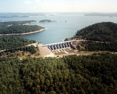
Broken Bow Lake is a reservoir in McCurtain County in southeastern Oklahoma that covers roughly 56.7 square kilometers and is surrounded by forested hills. The water is clear enough to see the bottom in many coves, and the jagged shoreline forms dozens of small inlets and peninsulas.

The Mountain Fork River was dammed in the late 1960s to control flooding and provide drinking water, requiring the relocation of the village of Hochatown. The reservoir filled by 1970 and opened shortly after for recreation and fishing.

Anglers gather here year-round and try their luck with pike and catfish living in the deep coves. Many families return each summer and rent the same spots along the shore, where they grill and swim.

Boat rentals and camping areas are spread along the northern and eastern shores, where most facilities and ramps are located. Visitors should bring drinking water and sun protection, as shaded areas outside the forested coves are limited.

Hiking trails like the David Boren Trail wind through pine forests to raised viewpoints that overlook hundreds of coves and islands. Some sections follow rocky ridges that rise above the water and offer views into remote arms that boats rarely reach.

The community of curious travelers

AroundUs brings together thousands of curated places, local tips, and hidden gems, enriched daily by 60,000 contributors worldwide.

Start exploring
Location
Elevation above the sea
144 m
GPS coordinates
34.18028,-94.68917
Latest update
December 5, 2025 22:29
Around this place
Beavers Bend Resort Park
United States of America

Beavers Bend Resort Park

5.5 km
Cossatot River State Park-Natural Area
United States of America

Cossatot River State Park-Natural Area

49.6 km
Little River National Wildlife Refuge
United States of America

Little River National Wildlife Refuge

27.1 km
St. Barnabas Episcopal Church
United States of America

St. Barnabas Episcopal Church

56.9 km
Mountain Fork Bridge
United States of America

Mountain Fork Bridge

47 km
Ebenezer Monument
United States of America

Ebenezer Monument

60.9 km
Mena City Hall
United States of America

Mena City Hall

61.1 km
Janssen Park
United States of America

Janssen Park

61 km
Oak Grove Rosenwald School
United States of America

Oak Grove Rosenwald School

60.8 km
Little Cossatot River Bridge
United States of America

Little Cossatot River Bridge

50.2 km
Hale Creek Bridge
United States of America

Hale Creek Bridge

47.7 km
Polk County Courthouse
United States of America

Polk County Courthouse

61.3 km
First United Methodist Church
United States of America

First United Methodist Church

53.8 km
Idabel Armory
United States of America

Idabel Armory

34 km
Judge Benjamin Shaver House
United States of America

Judge Benjamin Shaver House

60.7 km
DeQueen Commercial Historic District
United States of America

DeQueen Commercial Historic District

35.9 km
Hawkins House
United States of America

Hawkins House

57.4 km
Hayes Hardware Store
United States of America

Hayes Hardware Store

35.8 km
First Presbyterian Church
United States of America

First Presbyterian Church

35.5 km
Bishop Brookes House
United States of America

Bishop Brookes House

35.4 km
Mena Commercial Historic District
United States of America

Mena Commercial Historic District

61.2 km
Otis Theodore and Effiegene Locke Wingo House
United States of America

Otis Theodore and Effiegene Locke Wingo House

35.5 km
New Rocky Comfort Jail
United States of America

New Rocky Comfort Jail

57.7 km
King Schoolhouse
United States of America

King Schoolhouse

36.1 km
Gillham City Jail
United States of America

Gillham City Jail

34.6 km
Lockesburg Waterworks
United States of America

Lockesburg Waterworks

53.6 km
Beaver's Bend Mining Company
United States of America

Beaver's Bend Mining Company

6.6 km
State Theater
United States of America

State Theater

34.2 km
Show the full map
« Broken Bow Lake - Reservoir in McCurtain County, Oklahoma, United States » is provided by Around Us (aroundus.com). Images and texts are derived from Wikimedia project under a Creative Commons license. You are allowed to copy, distribute, and modify copies of this page, under the conditions set by the license, as long as this note is clearly visible.

Discover hidden gems everywhere you go!

From secret cafés to breathtaking viewpoints, skip the crowded tourist spots and find places that match your style. Our app makes it easy with voice search, smart filtering, route optimization, and insider tips from travelers worldwide. Download now for the complete mobile experience.

Around Us App Screenshot

A unique approach to discovering new places

Le Figaro

All the places worth exploring

France Info

A tailor-made excursion in just a few clicks

20 Minutes

Around Us
Travel Guide & Maps
Download

Send to your phone

QR Code
1

Open the camera app on your mobile.

2

Point at the QR code with your camera. A notification will appear.

3

Tap the notification to open the link.